Clay County, Alabama History
Clay County Education, Geography, and History
Clay County is a county of the state of Alabama. Based on the 2010 census, the population was 13,932. Clay County was created on December 7, 1866. The county was formed from Randolph County and Talladega County. The county seat is Ashland. Clay county is named in honor of Henry Clay, famous American statesman, member of the United States Senate from Kentucky and United States Secretary of State in the 19th century.
Etymology - Origin of Clay County Name
Clay county was named for US Senator Henry Clay of Kentucky.
Demographics:
County QuickFacts: CensusBureau Quick Facts
Clay County History
Clay County, Alabama
Clay county was formed by the Alabama Legislature on December 7, 1866. It is named for US Senator Henry Clay of Kentucky. The county is located in the east-central part of the state, in the foothills of the Appalachian Mountains. It encompasses 605 square miles. The Talladega National Forest is located in the western part of the county. The county seat is located at Ashland. Other communities include Lineville and Mellow Valley.
Clay county is a prohibition or dry county and currently the only dry county in Alabama with no wet cities within its boundaries.
Geography
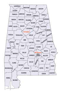
As reported by the Census Bureau, the county has a total area of 606 square miles (1,570 km2), of which 604 square miles (1,560 km2) is land and 2.0 square miles (5.2 km2) (0.3%) is water.
The Ketchepedrakee Creek, a tributary of the Tallapoosa River, flows
through the northern half of Clay county, and the Little Hillabee Creek,
a tributary of the Coosa River, flows through the southern half.
Hatchett Creek flows from north to south through the county.
Neighboring Counties
Bordering counties are as follows:
- Northeast: Cleburne County
- East: Randolph County
- South: Tallapoosa County
- Southwest: Coosa County
- Northwest: Talladega County
Places of interest
Clay County is home to parts of Cheaha State Park in the Talladega National Forest and Lake Wedowee on the eastern boundary. Outdoor
adventures abound in Clay County and the surrounding area. The Pinhoti Trail system weaves its way through the Talladega National Forest to
Mt. Cheaha, the highest point in Alabama. Hikers along the trail may spy some of the local wildlife, including whitetail deer, wild turkey,
and the rare bald eagle.
Home of Doc Hilt Trails for Off-Highway Vehicles. On May 5, 2010, Doc Hilt Trails was awarded the distinction of being a National Recreation
Trail. One of only two private motorized parks in the nation to ever be awarded the NRT designation.
Clay County has two sites listed on the National Register of Historic Places, the Hugo Black House (destroyed, but still listed) and the Clay
County Courthouse.
Education


