


Click Image to Enlarge
Alabama Counties
Alabama currently has sixty-seven counties. The oldest county, Washington, was created on June 4, 1800, when what is now Alabama was then part of the Mississippi Territory. The newest county is Houston, created on February 9, 1903.Greene County, Alabama History
Greene County Education, Geography, and History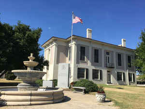
Greene County is a county in the state of Alabama. Based on the 2010 census, the population was 9,045 making it the least populous county in Alabama. Greene County was created on December 13, 1819, from part of the land ceded to the Federal government by the Choctaw Cession of October 24, 1816. and Marengo County and Tuscaloosa County. The county seat is Eutaw. Greene county named in honor of Revolutionary War General Nathanael Greene of Rhode Island.
Etymology - Origin of Greene County Name
Greene county bears the name of General Nathaniel Greene (Georgia), a hero of the American Revolution.
Demographics:
County QuickFacts: CensusBureau Quick Facts
Greene County History
Greene County, Alabama
Greene county was formed by the first state legislature on December 13, 1819 from part of the land ceded to the Federal government by the Choctaw Cession of October 24, 1816. The county bears the name of General Nathaniel Greene (Georgia), a hero of the American Revolution. Greene County is located in the west-central portion of the state, between the Tombigbee and Black Warrior Rivers. It is bordered by Pickens, Tuscaloosa, Hale, Marengo, and Sumter counties. It encompasses 631 square miles. The first county seat was located at Erie, now in Hale County. In 1838, the county seat was transferred to Eutaw. A fire occurred at the courthouse in 1868. Other towns and communities include Clinton and Boligee.
Geography: Land and Water
As reported by the Census Bureau, the county has a total area of 660 square miles (1,700 km2), of which 647 square miles (1,680 km2) is land and 13 square miles (34 km2) (1.9%) is water.
The Tombigbee River flows along the western border of the county, and its tributary, the Sipsey River Swamp flows along the northern border. Other tributaries of the Tombigbee, including Taylor, Brush, and Trussells creeks, also intersect the county. The Black Warrior River runs along the eastern border until it meets the Tombigbee at Demopolis, just below the southern tip of Greene County, in Marengo County. In 1958, the Warrior Dam was constructed on the Warrior River and created a cut-off canal across the neck of a horseshoe bend in the river. The canal leads barges to a separate lock about three-fourths of a mile southeast of the dam.
Neighboring Counties
Bordering counties are as follows:
- Northeast: Tuscaloosa County
- Southeast: Hale County
- South: Marengo County
- Southwest: Sumter County
- Northwest: Pickens County
Education


Click Image to Enlarge
