


Click Image to Enlarge
Alabama Counties
Alabama currently has sixty-seven counties. The oldest county, Washington, was created on June 4, 1800, when what is now Alabama was then part of the Mississippi Territory. The newest county is Houston, created on February 9, 1903.St. Clair County, Alabama History
St. Clair County Education, Geography, and History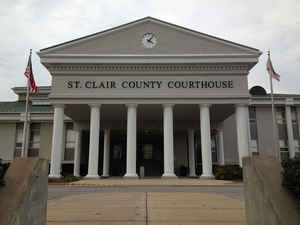
St. Clair County is a county of the state of Alabama. Based on the 2010 census, the
population was 85,593. St. Clair County was
created on November 20, 1818 and was formed from Shelby
County.This county has two county seats in
Ashville and another in Pell City. It is one of two counties in Alabama, and one of 33 in the United States, with more than one county seat.
St. Clair county is named in honor of General Arthur St. Clair, an officer in the French and Indian War.
St. Clair County is included in the Birmingham-Hoover, AL Metropolitan Statistical Area.
Etymology - Origin of St. Clair County Name
St. Clair county was named for General Arthur St. Clair (Pennsylvania), a hero of the American Revolution.
Demographics:
County QuickFacts: CensusBureau Quick Facts
St. Clair County History
St. Clair County, Alabama
St. Clair was formed by the Alabama Territorial legislature on November 20,
1818. It was named for General Arthur St. Clair (Pennsylvania), a hero of the American Revolution.
The county is located in the north-central part of the state, and is bordered by Blount, Calhoun, Talladega, Shelby, and Jefferson counties. It encompasses 646 square miles. St. Clair is the only county in Alabama to have two county seats. Ashville, originally called St. Clairsville, was named for John Ash, a senator in the state's first General Assembly. Located in the northern part of the county, Ashville served as the county seat from 1821-1907.
The Alabama Constitution of 1901 provided for Pell City in the southern part of the county to serve as the county seat for the Southern Judicial District of the county. A constitutional amendment in 1907 established Pell City, named for George H. Pell, an early settler, as the second county seat. Other towns and communities include Ragland and Springville.
Geography: Land and Water
As reported by the Census Bureau, the county has a total area of 654 square miles (1,690 km2), of which 632 square miles (1,640 km2) is land and 22 square miles (57 km2) (3.3%) is water.
The Coosa River runs along the eastern border of the county. Because the Coosa River is one of the most heavily used rivers in the state, much of its biological diversity is restricted to its tributaries, which fan out throughout the eastern half of St. Clair County. A series of locks and dams along the Coosa River provide business and recreational opportunities for the county. In addition, a number of tributaries of the Cahaba River flow throughout the western half of St. Clair County, creating scenic views and recreational opportunities.
Neighboring Counties
Bordering counties are as follows:
- Northeast: Etowah County
- East: Calhoun County
- Southeast: Talladega County
- Southwest: Shelby County; Jefferson County
- Northwest: Blount County
Places of interest
St. Clair County is home to Logan Martin Lake. It also contains Horse Pens 40, a private outdoor park on top of Chandler Mountain.
Education


Click Image to Enlarge
