Talladega County, Alabama History
Talladega County Education, Geography, and History
Talladega County is a county of the state of Alabama. Based on the 2010 census, the
population was 82,291.Talladega County was
created on December 18, 1832, from land ceded by the Creek
Indians by the Creek Cession of 1832. The county
seat is Talladega. Talladega county was named
for Talatigi, Creek Indian name for the county seat, meaning "border
town".
Talladega County is included in the Talladega-Sylacauga, AL Micropolitan Statistical Area, which is also included in the
Birmingham-Hoover-Talladega, AL Combined Statistical Area.
Etymology - Origin of Talladega County Name
The county is named for a Creek Indian village. The name Talladega is derived from a Muscogee (Creek) Native American word Tvlvteke, from the Creek tålwa, meaning "town", and åtigi, or "border" - "Border Town"?#8364;"a town indicating its location on the boundary between the lands of the Creek tribe and those of the Cherokee and Chickasaw
Demographics:
County QuickFacts: CensusBureau Quick Facts
Talladega County History
Talladega County, Alabama
Prior to Euro-American settlement in what is today Talladega County it was the home of the Abihka tribe of the Creek Confederacy.
Talladega county was formed by an act of the Alabama General Assembly on December 18, 1832, from land ceded by the Creek Indians. The county is located near the geographic center of the state, in the Coosa River Valley. It encompasses 753 square miles. The county is named for a Creek Indian village. The county seat was established at Talladega in 1834. Other significant towns include Sylacauga, Childersburg, Sycamore and Lincoln.
Geography: Land and Water
As reported by the Census Bureau, the county has a total area of 760 square miles (2,000 km2), of which 737 square miles (1,910 km2) is land and 24 square miles (62 km2) (3.1%) is water. It is drained by Chockolocko Creek and other streams.
The Coosa River and its tributaries run throughout Talladega County.
The Coosa is one of the most utilized rivers in the state, so much of
the river's diversity is restricted to its tributaries, which fan out
throughout the county. A series of locks and dams along the Coosa River
provide business and recreational opportunities for the county.
Neighboring Counties
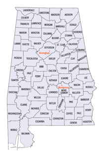
Bordering counties are as follows:
- Northeast: Calhoun County; Cleburne County
- Southeast: Clay County
- South: Coosa County
- Southwest: Shelby County
- Northwest: St. Clair County
Education
The Birmingham Supplementary School Inc., a part-time Japanese school, has its office is at the Honda Manufacturing of Alabama, LLC facility in unincorporated Talladega County, near Lincoln. It holds its classes at the Shelby-Hoover campus of Jefferson State Community College in Hoover. The school first opened on September 1, 2001


