

Click Image to Enlarge
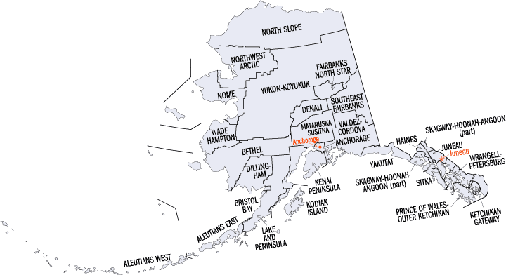
Alaska Boroughs
Alaska is divided into nineteen organized boroughs and one "Unorganized Borough." The Borough Act of 1961 created "The Unorganized Borough" including all of Alaska not within a Unified, Home rule, First class or Second class Borough. The newest borough is Petersburg incorporated after voters approved borough formation in December 2012. Alaska and Louisiana are the only states that do not call their first-order administrative subdivisions counties (Louisiana uses parishes instead)Haines Borough, Alaska
Haines Borough Education, Geography, and History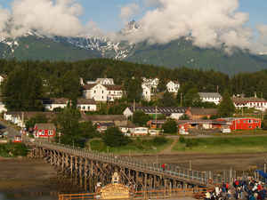
Haines Borough is a home-rule borough located in the state of Alaska. Based on the 2010 census, the population was 2,508. Haines Borough was created in 1968. The borough seat is Haynes. Haines Borough was named after Haines, which was itself named for Mrs. F.E. Haines, the key fundraiser for the construction of a Presbyterian mission in the town.
Etymology - Origin of Haines Borough Name
The mission was renamed Haines in 1884 in honor of Mrs. F. E. Haines, the chairwoman of the committee that raised funds for its building. In 1881, the Chilkat asked Sheldon Jackson to send missionaries to this area. One of the missionaries sent was S. Young Hall, a Presbyterian minister. He built the Willard mission and school at Dtehshuh, on land that was given by the Chilkat.
Demographics:
County QuickFacts: CensusBureau Quick Facts
History of Haines Borough, Alaska
A look at Haines Borough today used to be called "'Dtehshuh" or "end of the trail" by the Chilkat group of Tlingit. It received this name because they could portage (carry) their canoes from the trail that they use to trade with the interior, which began at the outlet of the Chilkat River, to Dtehshuh and save (20 miles) of rowing around the Chilkat Peninsula. George Dickinson, an agent for the North West Trading Company, settled at Dtehshuh around 1880. In 1881, the Chilkat asked Sheldon Jackson to send missionaries to this area. One of the missionaries sent was S. Young Hall, a Presbyterian minister. He built the Willard mission and school at Dtehshuh, on land that was given by the Chilkat. The mission was renamed Haines in 1884 in honor of Mrs. F. E. Haines, the chairwoman of the committee that raised funds for its building.
Four canneries were constructed around the mission by the 1900. During the Klondike Gold Rush from 1898 to1899, Haines grew as a supply center, since the Dalton Trail from Chilkat Inlet offered a route to the Yukon for prospectors. Gold was also discovered 36 miles from Haines in 1899 at the Porcupine District. During this time, the name Haines came into use for this area around the mission and not for just the mission itself. With the finishing of the White Pass and Yukon Route railway in neighboring Skagway, the Dalton Trail was mostly abandoned and Haines declined economically.
Fort William H. Seward, a United States Army installation was constructed south of Haines around 1904, on property that was donated by the mission from its holdings. In 1922, the fort was renamed Chilkoot Barracks. It was the only United States Army post in Alaska before World War II. During World War II, it was used as a supply point for some U. S. Army activities in Alaska. The fort was deactivated in 1946 and sold as surplus property to a private group who called it Port Chilkoot. In 1970, Port Chilkoot merged with Haines into one municipality. In 1972, the fort was designated a national historic site and renamed to, Fort William H. Seward, was restored.
The last of the four canneries closed in 1972 due to declining of fish stocks. Logging and sawing timber has been an industry around Haines but has declined in recent years. Tourism is now an important source of income in the community. Many tourists visit during the annual appearance of bald eagles in the Alaska Chilkat Bald Eagle Preserve between October and February Calendar year.
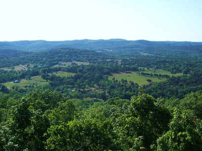
Geography: Land and Water
The borough has a total area of 2,726 square miles (7,060 km2), of which 2,319 square miles (6,010 km2) is land and 407 square miles (1,050 km2) (14.9%) is water.
Alaska's Inside Passage, shaped by the force of enormous glaciers millions of years ago, claims wildlife-filled fjords and lush island scenery. This borough is a habitat for whales, sea lions, bald eagles, and porpoises. Its mountains are carpeted with grand forests. Inside Passage is home to Tsimshian, Haida and Tlingit Indians, whose history is imitated in towering totem poles. Russian settlers left a legacy of onion-domed churches shining with images.
Neighboring Boroughs
Bordering boroughs are as follows:
- Juneau City and Borough, Alaska - south
- Skagway-Hoonah-Angoon Census Area, Alaska - west
Also shares eastern border with British Columbia, Canada.
- Stikine Region, British Columbia
Items of interest
Around November of each year, thousands of eagles descend en masse to feast on one of the salmon runs. Many photographers come to attain easily accessible photos of eagles.
Education


Click Image to Enlarge
