

Click Image to Enlarge
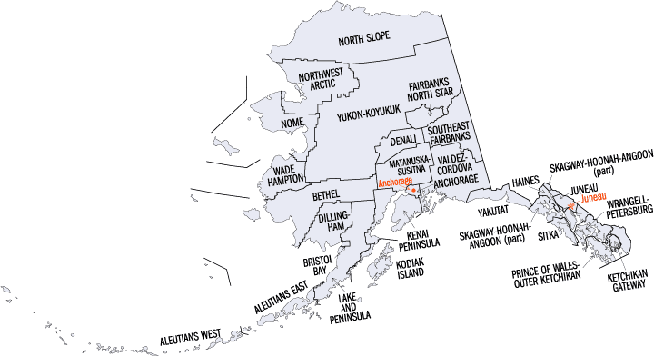
Alaska Boroughs
Alaska is divided into nineteen organized boroughs and one "Unorganized Borough." The Borough Act of 1961 created "The Unorganized Borough" including all of Alaska not within a Unified, Home rule, First class or Second class Borough. The newest borough is Petersburg incorporated after voters approved borough formation in December 2012. Alaska and Louisiana are the only states that do not call their first-order administrative subdivisions counties (Louisiana uses parishes instead)Kodiak Island Borough, Alaska
Kodiak Island Borough Education, Geography, and History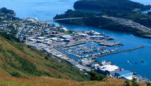
Kodiak Island Borough is a borough located in the state of Alaska. Based on the 2010 census, the population was 13,592. The borough seat is Kodiak. The borough was created in 1963. Kodiak Island Borough was named after Kodiak Island, which may itself be named for the Koniag people.
Etymology - Origin of Kodiak Island Borough Name
Kodiak is the ancestral land of the Koniaga, an Alutiiq nation. The original inhabitants subsisted by hunting, fishing, farming and gathering. The first Westerners to settle on the island were Russians explorers under Grigory Shelikhov, who founded a Russian settlement on Kodiak Island at Three Saints Bay, near the present-day village of Old Harbor, in 1784.
Demographics:
County QuickFacts: CensusBureau Quick Facts
History of Kodiak Island Borough, Alaska
Kodiak Island has been inhabited since 8,000 B.C. and was settled by Russian fur trappers around 1792. The sea otter pelts were the primary
enticement for Russian exploration at that time. Kodiak was the first capital of Russian Alaska, which moved to Sitka when Alaska was purchased by the US around 1867. Since the Aleutian Campaign of World War II, several branches of the military have maintained a presence in Kodiak. The 1960s brought growth in commercial fisheries and fish processing. The Borough was incorporated in 1963.
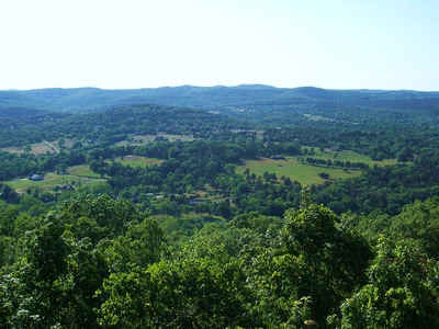
Kodiak Island is located on the eastern side of the Gulf of Alaska. It about 252 air miles south of Anchorage, and a 55 minute flight, and is a three hour flight from Seattle Washington. Kodiak Island is approximately 57.783330° North Latitude and -152.40 West Longitude. Kodiak Island Borough is located in the Kodiak Recording District. The area encompasses 6,559.8 sq. miles of land and 5,463.8 sq. miles of water. The climate of the Kodiak Islands is dominated by a strong marine influence. There is little or no freezing weather, moderate precipitation, and frequent cloud cover and fog. Severe storms are common from December through February yearly. Yearly precipitation is about sixty inches on the windward side of the Island, and forty inches on the leeward side. Temperatures remain within a narrow range, from 32 to 62.
The Island culture is grounded in commercial and subsistence fishing activities and is primarily non-Native. A Russian Orthodox Church seminary is based in Kodiak, one of the two existing seminaries of this kind in the US The Coast Guard comprises a significant portion of the Borough.
The Coast Guard, City, Borough, State and federal agencies also provide employment. 767 borough residents hold commercial fishing permits. Subsistence activities and sport fishing are prevalent. The Kodiak Launch Complex, a $38 million low-Earth orbit launch facility on 27 acres, was recently completed at Cape Narrow near Chiniak. The Kodiak Launch Complex, operated by the Alaska Aerospace Dev. Corp., is the only commercial launch range in the US that is not co-located with a federal facility.
Geography: Land and Water
The borough has a total area of 12,022 square miles (31,140 km2), of which 6,550 square miles (17,000 km2) is land and 5,472 square miles
(14,170 km2) (45.5%) is water.
Most of the land area belongs to Kodiak Island, but a thin strip of coastal area on the western part of the Alaska Peninsula and other nearby
islands (Afognak Island, Shuyak Island, Marmot Island, Raspberry Island, Little Raspberry Island, Whale Island, Spruce Island, Woody Island,
Uganik Island, Sitkalidak Island, Tugidak Island, Sitkinak Island, Chirikof Island, and the Semidi Islands) are also in the borough. The
waterway between the island and mainland is known as the Shelikof Strait. South of the island are the open waters of the Pacific Ocean, so the
site is considered good for launching certain types of satellites. The Kodiak Launch Complex is ideal for putting satellites in Molniya and
polar orbits.
Neighboring Boroughs:
- Lake and Peninsula Borough, Alaska - northwest
Education


Click Image to Enlarge
