

Click Image to Enlarge
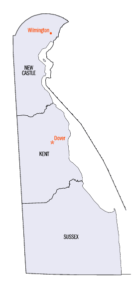
Delaware Counties
Delaware has three counties: New Castle, Kent, and Sussex, the fewest Counties of any US state. The origin of the county boundaries go back to former court districts. The powers of the counties' legislative bodies are limited to issues such as zoning and development.New Castle County, Delaware
New Castle County Education, Geography, and History
New Castle County is the northernmost of the three counties of the state of Delaware. Based on the 2010 census, the
population was
538,479, making it the most populous county in Delaware. New Castle
County was created on August 8, 1673 as an Original
County (originally named New Amstel County until 1674). The county
seat is Wilmington. The county was named
by Dutch Governor Anthony Colve for the town of New Castle, Delaware
as an Anglicization of Nieuw Amstel.
New Castle County is included in the Philadelphia-Camden-Wilmington, PA-NJ-DE-MD Metropolitan Statistical Area. This county is named after
the English city of Newcastle.
Etymology - Origin of New Castle County Name
New Castle was named in 1673 by Dutch Governor Anthony Colve for the town of New Castle, Delaware.
Demographics:
County QuickFacts: CensusBureau Quick Facts
New Castle County History
The first permanent settlement on Delaware soil was Fort Christina, resulting from Peter Minuit's 1638 expedition
in the Kalmar Nyckel. The town was laid out where Wilmington presently exists, and the land contracted with the
Indians consisted of Old Cape Henlopen north to Sankikans (Trenton Falls), and inland as far as they desired.
However, a dispute ensued between the Swedes and the Dutch, who stated they had prior claim to that land.
In 1640, New Sweden was founded a few miles south of Christina, and in 1644, Queen Christina appointed Lt. Col.
Johan Printz as Governor of New Sweden. She directed boundaries to be set and to reach Cape Henlopen north along the
west side of Godyn's Bay (Delaware Bay), up the South River (Delaware River), past Minquas Kill (Christina River),
to Sankikans (Trenton Falls). Printz settled on Tinicum Island, making it the seat of government and capital of New
Sweden.
Peter Stuyvesant, Governor of New Netherland, sailed up the South River in 1651. He purchased land from the Indians
that covered Minquas Kill to Bompties Hook (Bombay Hook), part of this purchase had already been sold to the Swedes
in 1638. Stuyvesant, unaware of any dishonesty, began to build Fort Casimir (contemporary New Castle).
In 1654, John Rising, Commissary and Councilor to the Governor Lt. Col. Printz, officially assumed Printz's duties
and began to extricate all Dutch from New Sweden. Fort Casimir surrendered and was renamed Fort Trinity in 1654. The
Swedes were now in complete possession of the west side of the Delaware River. On June 21, 1654, the Indians met
with the Swedes to reaffirm the purchase.
The Dutch, having learned of the fall of Fort Casimir, sent Stuyvesant to drive the Swedes from both sides of the
river. Only the Dutch were allowed to settle in the area and on August 31, 1655, the territory was converted back to
Fort Casimir. Consequently, Fort Christina fell on September 15th and New Netherland ruled once again. John Paul
Jacquet was immediately appointed Governor, making New Amstel the capital of the Dutch-controlled colony.
As payment for regaining the territory, Dutch West India Company conveyed land from the south side of Christina Kill
to Bombay Hook, and as far west as Minquas land. This land was known as the Colony of The City. On December 22,
1663, the Dutch transferred property rights to the territory along the Delaware River to England. In 1664, the Duke
of York, James, was granted this land by King Charles II. One of the first acts by the Duke was to order removal of
all Dutch from New Amsterdam; the name was then changed from New Amstel to New Castle. In 1672, the town of New
Castle was incorporated and English law ordered. However, in 1673, the Dutch attacked the territory, reclaiming it
for their own
When during Dutch rule, Governor Colve, set up three district courts of Upland (Chester, Pennsylvania), New Castle, and Hoornkill (Kent and Sussex Counties).
On September 12, 1673, the Dutch established New Amstel in present-day Delaware, fairly coterminous with today's
New Castle County. The establishment was not stable, however, and it was transferred to the British under the Treaty
of Westminster on February 9, 1674.
On November 6, 1674, New Amstel was made dependent on New York Colony, and was renamed New Castle on November 11,
1674.
On September 22, 1676, New Castle County was formally placed under the Duke of York's laws. It gained land from
Upland County on November 12, 1678.
On June 21, 1680, St. Jones County was carved from New Castle County. It is known today as Kent County, Delaware.
On August 24, 1682, New Castle County, along with the rest of the surrounding land, was transferred from the Colony
of New York to the possession of William Penn, who established the Colony of Delaware.
Source: NEW YORK: Atlas of Historical County Boundaries by Kathryn Ford Thorne and John H. Long.
The General Assembly in 1681, under William Penn, officially named the counties New Castle, Kent and Sussex. Today the biggest cities in the county are Wilmington and Newark.
Geography: Land and Water
As reported by the Census Bureau, the county has a total area of 494 square miles (1,278 km2).426 square miles (1,104 km2) of it is land, and 67 square miles (174 km2) of it (13.62%) is water.
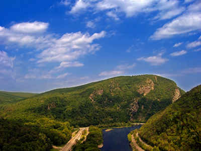
New Castle county is located in north Delaware. The highest natural point in Delaware, Ebright Azimuth at 451 feet (137 m), is located in New Castle County. The Ebright Azimuth is located about 6.5 miles (10.5 km) north of downtown Wilmington, Delaware. The Chesapeake and Delaware Canal was built through New Castle County, and adjoining Cecil County, Maryland, between 1822 and 1829.
Neighboring Counties
Bordering counties are as follows:
- North: Chester County, Pa.
- Northeast: Delaware County, Pa.; Gloucester County, N.J.
- East: Salem County, N.J.
- Southeast: Delaware Bay
- South: Kent County
- Southwest: Kent County, Md.
- West: Cecil County, Md.
Education


Click Image to Enlarge
