


Click Image to Enlarge
Illinois Counties
There are one hundred and two counties in Illinois. St. Clair County was the first county established in what is today Illinois. Most counties in Illinois were named after early American leaders, especially of the American Revolutionary War, as well as soldiers from the Battle of Tippecanoe and the War of 1812.Cumberland County, Illinois
Cumberland County Education, Geography, and History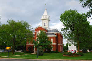
Cumberland County is a county located in the state of Illinois. Based on the 2010 census, the
population was 11,048. Cumberland County was
created on March 2, 1843. The county seat is
Toledo. The county is named for the Cumberland road,
named in its turn from the town Cumberland, Maryland, which derived its
name from the mountain range of the same name adopted, presumably, from
the Cumberland mountains of Great Britain.
Cumberland County is part of the Charleston-Mattoon, IL Micropolitan Statistical Area.
Etymology - Origin of Cumberland County Name
The county derived its name from the Cumberland or National Road which was a 19th-century highway extending 800 miles from Cumberland, Maryland to Vandalia, Illinois. The Cumberland Road name is derived from the Cumberland mountains of Great Britain.
Demographics:
County QuickFacts: CensusBureau Quick Facts
Cumberland County History
Cumberland County is named after the famed Cumberland Road, construction of which by the United States Government to
be one of the chief factors in the development and growth of the west. This great national highway, extending from the
Potomac almost to the Mississippi, was first authorized by Congress, after being favorably reported by the Senate
Committee, in an act "to regulate the laying out and making a road from Cumberland in the State of Maryland, to the
State of Ohio," the act being approved by President Thomas Jefferson, March 29, 1805.
The first contracts were let on April 11th and 16th 1811, and by 1818 United States Mail coaches were running between
Washington, D.C. and Wheeling, Virginia. By the time building operations began in Illinois, around 1830, emigration,
given tremendous impetus by the extension of the road to what was then the far west, was in full swing. The Cumberland
Road reached what is now Cumberland County about 2835, and ended at Vandalia, fifty-five miles away, about three years
later.
The formation of Cumberland County arose from the dissatisfaction of early settlers over the long distance to be
traveled to Darwin, the county seat and center of trade of Coles County. business men of Greenup, hoping to promote
their own village as the prospective county seat, were the chief agitators for the change.
When the feeling of dissatisfaction finally culminated in the demand for the creation of a new county, two factions
opposed one another. Settlers of Charleston demanded that the county of Coles be divided into three equal parts, which
would result in the creation of two new counties the Greenup contingent, as well as others, insisted upon a division in
two equal parts, or the creation of only one new county. The two propositions were known respectively as the "crop" and
the "split". Candidates were put up by both sides, and in 1842, after much spirited campaigning, the declaration of E.H.
Starkweather, one of the leaders in the fight, for the "split" resulted in the creation of the new county of Cumberland
by act of legislature, March 2, 1843.
The Act designated the boundary lines, set the date and place for the first election, and named the village of Greenup
as the seat of justice until a permanent county seat should be selected according to the terms set forth in the Act. The
first election was held on the first Monday of the following April, and resulted in the choice of the following
officers: Sheriff, Thomas Scones; Coroner, Hiram Buell; County Surveyor, Judson E. Holly; Probate Judge, E.E.
Starkweather; County Recorder, Otis Perry; Treasurer, Abrah Trease; School Commissioner, Daniel C. Docius; County
Commissioners, James Gill, Charles P. Chowning, and David P. Wisnor; J. Ewart was appointed Clerk of the County
commissioners' Court.
The first session of the county commissioners court, a special term, was held May 1 1843, and one of the first acts was
an order on the treasurer to pay the sum of fourty dollars to William Price, who had loaned the county two hundred
dollars with which to defray current expenses and purchase books and stationery. This sum was to be paid out of the
first money received by the treasurer.
Inaccordance with the requirements of the act of creation, an election was held on the first Monday in August to
determine the location of the county seat. At this election DeKalb received a majority of the votes. James Gill and
Thomas Scones gave bond for the donation of De Kalb, but it was subsequently discovered that the title was not clear.
Despite considerable controversary, De Kalb went ahead with its plans, even to the extent of hauling logs to begin
building operations. The rival village of Greenup, however, making capital of the encumbered title, finally secured the
county seat. They managed to hold on to it until 1855, when it was removed to Prairie City, which had been laid off in
April, 1843 by N. Berry, John Berry, L. Harvey and W.P. Rush. fighting a losing battle, Greenup stubbornly sought to
retain the seat of justice by refusing to give up the official records, and it was not until 1857 that all the county
records were finally removed.
During the time Greenup was county seat there were no public buildings, the county seat and clerk of the circuit court
being furnished temporary quarters by JamesEwart. A house later secured from Daniel Porter, served as the courthouse for
the next ten years. The circuit court was somiciled in an old log schoolhouse, and here court was held and cases tried
by men who later became famous as statesmen not only in Illinois, but throughout the nation. among them was Abraham
Lincoln, who tried many of his cases here, including the famous "Lustre Case".
When in 1855, Prairie City succeeded in wresting the seat of justice from Greenup, one of the stipulations provided for
the erection of public buildings. accordingly, a contract was let to Filey Ross and Bennet Beale to build a courthouse,
the contract providing that the building be forty feet square and the walls twenty-seven feet high. the specifications
called for three doors, nineteen windows, and a cupola with a bell that could be heard for five miles. There was so much
opposition to all this by the county clerk, that he did not record the contract, and it did not appear on the
commissioners' journal until a new clerk was elected and recorded it is 1857. The first courthouse was destroyed by fire
in the early part of 1885; the second erected the same year, is still being used. It is a two and one half story brick
building with stone trimmings, seventy two feet long, seventy-two feet wide, and forty-two feet high.
The first jail, a single, two story building of brick, twenty by thirty-two feet and including the jailers quarters, was
constructed in 1859 as a result of a prisoner's escape. Prior to this time a jail had been thought to be unnecessary, as
the Sheriff used an old "gum" which stood in his yard. This had a wire netting over the top, and in the opinion of the
sheriff, a prisoner was as safe there as in a jail. Finally one prisoner, in an attempt to escape, climbed to the top,
but as he was getting the wire netting off, the "gum" toppled over into the river. this was considered as easy a way as
any of releasing him, and no effort was made to recapture him.
In 1859 Cumberland elected to adopt the township form of county government, the administrative county court being
succeeded by the first county board of supervisors, elected in April 1861 representing eight townships. In the early
part of 1874, the name of the county seat was changed from Prairie city to Toledo.
Cumberland is strictly an agricultural county, but in the vicinity of Greenup is found potter's clay which makes a fair
quality of stoneware, there is also some copper, but not in sufficient quantify to warrant mining.
Cumberland county lies in the south tier of the area improperly called Central Illinois, on the border of the section
known as Egypt. It is bounded on the north by Coles County, on the east by Clark, on the south by Jasper and Effingham,
and on the west by Shelby and Moultris. It has an area of 350 square miles, and according to the 1930 census, the
population is 10,419.
Geography: Land and Water
As reported by the Census Bureau, the county has a total area of 347 square miles (899 km2), of which 346 square miles (896 km2) is land and 1 square mile (3 km2) (0.28%) is water.
Cumberland county is located in southeast Illinois.
Neighboring Counties
Bordering counties are as follows:
- North: Coles County
- East: Clark County
- Southeast: Jasper County
- Southwest: Effingham County
- Northwest: Shelby County
Education


Click Image to Enlarge
