


Click Image to Enlarge
Illinois Counties
There are one hundred and two counties in Illinois. St. Clair County was the first county established in what is today Illinois. Most counties in Illinois were named after early American leaders, especially of the American Revolutionary War, as well as soldiers from the Battle of Tippecanoe and the War of 1812.Hardin County, Illinois
Hardin County Education, Geography, and History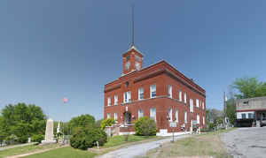
Hardin County is a county located in the state of Illinois. According to the 2010 census, it has a population of 4,320, making it the least populous county in Illinois. Hardin County was created on March 2, 1839. The county seat is Elizabethtown. The county is named for Hardin County, Kentucky, which was itself named after John Hardin.
Etymology - Origin of Hardin County Name
The county is named for Hardin County, Kentucky, which was itself named after John Hardin.
Demographics:
County QuickFacts: CensusBureau Quick Facts
Hardin County History
Hardin County was created on March 2, 1839 (Laws, 1839, p. 234) and was formed from Gallatin and Pope Counties.
Present area, or parts of it, formerly included in: Gallatin County (1812-1839), Pope County (1816-1839), Randolph
County (1801-1812) and Knox, Northwest Territory (1790-1809).
The County was named for Hardin County in Kentucky through the influence of emigrants from that county. Hardin County,
Kentucky, which was named for John Hardin, an officer in the Revolutionary War and Northwest Indian War. John Hardin was
killed by Shawnee Indians in 1792 in what is now Shelby County, Ohio.
The County Seat is Elizabethtown (1840-Present).
In 1801 to 1809, the territory that was Gallatin County split between the counties of Randolph and Knox. Everything East of the line running north from Cave In Rock remained "Old Knox County" with Vincennes as the County Seat. This territory consisted of a fourth of Hardin County, the mouth of the Saline River, as well as the area of Old Shawneetown and New Haven. Gallatin was reduced several times. Franklin county was organized in 1818, White county in 1815 and Hardin county in 1839. Around the 1700's, Gallatin and Hardin county were one of the same. The history of this area couldn't possibly be told in a few paragraphs and to do it justice, would take a few years. I will say that the little bit of what I've read is truly amazing and never ceases to hold my intrigue. This area is one of the few and oldest in Illinois. The history here ranges from the Mound Builders, there are two in the area you should see, Boyd's Mound and Rutherford's Mound near Saline, to the Shawnee Indians, the famous Cherokee Trail of Tears, the beginnings of Slavery in Illinois (salt licks), to the First Federal Bank. Other stories contain history on the Cave in Rock, to the haunting of the Old Slavery House and of course, Abraham Lincoln. I'm sure there is more...once I've research further...and I will do my best to touch on them all. Illinois is so rich in history and when you visit these areas... it's easy to fall back into time. The beauty of the Shawnee Forest in itself could put you right there! History books for Hardin County are hard to come by, but I have managed to collect a few. I have been there a couple years back, but I feel it requires another visit in the Spring. I can't wait to see Elizabethtown again and enjoy some of that sweet hospitality and that awesome fried chicken! (for research purposes of course!)
Contributed by Deanna Heneghan, former Hardin county host.
Geography: Land and Water
As reported by the Census Bureau, the county has a total area of 182 square miles (470 km2), of which, 178 square miles (462 km2) of it is land and 3 square miles (8 km2) of it (1.76%) is water.
Hardin county is located in south Illinois. Hicks Dome is a
geological feature in Hardin County. The dome may be related to an
ancient meteor or comet impact, part of the 38th parallel structures,
which are a string of geological features running west to Kansas. This
is thought to be a string of impact craters from a celestial body that
broke apart before striking the earth. Most geologists now accept the
theory that the older rocks at the center of the uplift are a result of
this deep seated igneous activity. This activity may also have provided
the fluorine in the fluorspar deposits in the region. Fluorspar, or
calcium fluoride, was mined in Hardin County until the early 1990s.
Cave-in-Rock State Park is located in Hardin county.
Neighboring Counties
Bordering counties are as follows:
- North: Gallatin County
- Northeast: Union County, Ky.
- Southeast: Crittenden County, Ky.
- South: Livingston County, Ky.
- Southwest: Pope County
- Northwest: Saline County
Education


Click Image to Enlarge
