


Click Image to Enlarge
Illinois Counties
There are one hundred and two counties in Illinois. St. Clair County was the first county established in what is today Illinois. Most counties in Illinois were named after early American leaders, especially of the American Revolutionary War, as well as soldiers from the Battle of Tippecanoe and the War of 1812.Madison County, Illinois
Madison County Education, Geography, and History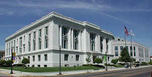
Madison County is a county located in the state of Illinois. According to the 2010 census, it had a
population of 269,282. Madison County was
created on September 14, 1812. The county
seat is Edwardsville, and its largest city is Granite City.
The county is named for James Madison (1751-1836),
fourth President of the United States and principal author of the
Constitution of the United States.
Madison County is part of the Metro-East region of the St. Louis, MO-IL Metropolitan Statistical Area.
Etymology - Origin of Madison County Name
The county is named for President James Madison, known as the father of the United States Constitution, who fought for a strong central government to replace the Articles of Confederation.
Demographics:
County QuickFacts: CensusBureau Quick Facts
Madison County History
Madison County was established on September 14, 1812. It was formed out of Randolph and St. Clair Counties and named for James Madison. At the time of its formation, Madison County included all of the modern State of Illinois north of St. Louis, about three-fourths of the Territory.
Geography: Land and Water
As reported by the Census Bureau, the county has a total area of 1,918 km2 (740 mi2). 1,878 km2 (725 mi2) of it is land and 40 km2 (15 mi2) of it (2.07%) is water.
Madison county is located in south Illinois. The county is on the Mississippi River, while the other
major body of water is Horseshoe Lake. Horseshoe Lake State Park and Lewis
and Clark State Historic Site are located in this county.
Neighboring Counties
Bordering counties are as follows:
- North: Macoupin County
- Northeast: Montgomery County
- East: Bond County
- Southeast: Clinton County
- South: St. Clair County
- Southwest: St. Louis city, Mo.; St. Louis County, Mo.
- West: St. Charles County, Mo.
- Northwest: Jersey County
Education


Click Image to Enlarge
