


Click Image to Enlarge
Illinois Counties
There are one hundred and two counties in Illinois. St. Clair County was the first county established in what is today Illinois. Most counties in Illinois were named after early American leaders, especially of the American Revolutionary War, as well as soldiers from the Battle of Tippecanoe and the War of 1812.Pike County, Illinois
Pike County Education, Geography, and History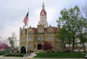
Pike County is a county located in the state of Illinois. According to the 2010 census, it had a population of 16,430. Pike County was created on January 31, 1821. The county seat is Pittsfield. The county is named for Zebulon Pike (1779-1813), early explorer of the American Southwest, namesake of Pikes Peak. Pike county is located in west Illinois.
Etymology - Origin of Pike County Name
The county is named for Zebulon M. Pike, general in the War of 1812, and American explorer after whom Pikes Peak in Colorado was named.
Demographics:
County QuickFacts: CensusBureau Quick Facts
Pike County History
Pike County was created on January 31, 1821 (Laws, 1821, p. 59) and was formed from Madison County . Present area, or
parts of it, formerly included in: Madison County (1812-1821) and St. Clair County 1795-1812).
The County was named for Zebulon Pike, an early explorer of the Louisiana purchase. Pike's Peak was named in his honor.
He was a General of the War of 1812 and was killed at York, Canada. The County Seat is Pittsfield. Prior County Seats
was Coles' Grove- Now Gilead in Calhoun County (1821-1824), Atlas (1824-1833) and Pittsfield (1833-Present).
Geography: Land and Water
As reported by the Census Bureau, the county has a total area of 849 square miles (2,199 km2), of which, 830 square miles (2,150 km2) of it is land and 19 square miles (48 km2) of it (2.19%) is water.
Pike county is located in west Illinois. Pike County is located
on the highlands between the Illinois River on the eastern border, and
the Mississippi River on the west.
Neighboring Counties
Bordering counties are as follows:
- Northeast: Brown County
- East: Morgan County; Scott County
- Southeast: Greene County; Calhoun County
- Southwest: Pike County, Mo.
- West: Ralls County, Mo.
- Northwest: Marion County, Mo.; Adams County
Education


Click Image to Enlarge
