


Click Image to Enlarge
Illinois Counties
There are one hundred and two counties in Illinois. St. Clair County was the first county established in what is today Illinois. Most counties in Illinois were named after early American leaders, especially of the American Revolutionary War, as well as soldiers from the Battle of Tippecanoe and the War of 1812.Stark County, Illinois
Stark County Education, Geography, and History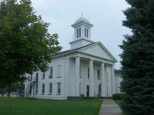
Stark County is a county located in the state of Illinois. According to the 2010 census, it had a
population of 5,994. Stark County was
created on March 2, 1839. The county seat
is Toulon. The county is named for General John Stark
(1728-1822), general in the American Revolutionary War, called the "Hero
of Battle of Bennington".
Stark County is part of the Peoria, IL Metropolitan Statistical Area.
Etymology - Origin of Stark County Name
The county is named for General John Stark, revolutionary soldier; won fame at Bunker Hill, Trenton, Princeton and Bennington.
Demographics:
County QuickFacts: CensusBureau Quick Facts
Stark County History
Stark County was created on March 2, 1839 (Laws, 1839, p. 229) and was formed from Knox and Putnam Counties. Present
area, or parts of it, formerly included in: Putnam County (1825-1839), Knox County (1829-1839), Fulton County
(1823-1825), Pike County (1821-1823), Madison County (1812-1821) and St. Clair County (1801-1812).
The County was named for John Stark, a soldier of the French and Indian wars, a Major General of the Revolution, who
served with distinction at Bunker Hill, Trenton, Princeton, and Bennington. The County Seat is Toulon (1841-Present).
The History of Bureau County (Taken From the Earliest Historical Facts of Marshall-Putnam Counties, Also Bureau and Stark Counties,
Compiled and Published by Mr. Henry A. Ford, 1860)
Chapter II: The History of Illinois 1690-1825 and Chapter V: The Black Hawk War
Chapter I: European Discovery in the West
Geography: Land and Water
As reported by the Census Bureau, the county has a total area of 288 square miles (746 km2), of which, 288 square miles (746 km2) of it is land and 0 square miles (1 km2) of it (0.10%) is water.
Stark county is located in northwest Illinois. Part of Rock Island
Trail State Park is located in this county.
Neighboring Counties
Bordering counties are as follows:
- Northeast: Bureau County
- East: Marshall County
- South: Peoria County
- Southwest: Knox County
- Northwest: Henry County
Education


Click Image to Enlarge
