


Click Image to Enlarge
Illinois Counties
There are one hundred and two counties in Illinois. St. Clair County was the first county established in what is today Illinois. Most counties in Illinois were named after early American leaders, especially of the American Revolutionary War, as well as soldiers from the Battle of Tippecanoe and the War of 1812.Woodford County, Illinois
Woodford County Education, Geography, and History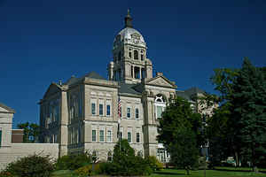
Woodford County is a county located in the state of Illinois. According to the 2010 census, it had a
population of 38,664. Woodford County was
created on February 27, 1841. The county
seat
is Eureka. The county is named for General William
Woodford (1734-1780), brigadier general in the American Revolutionary
War who died while a British prisoner.
Woodford County is part of the Peoria, IL, Metropolitan Statistical
Area.
Etymology - Origin of Woodford County Name
The county is named for General William Woodford (1734-1780), brigadier general in the American Revolutionary War who died while a British prisoner.
Demographics:
County QuickFacts: CensusBureau Quick Facts
Woodford County History
Woodford County was created on February 27, 1841 (Laws, 1841, p. 84) and was formed from McLean and Tazewell
Counties. Present area, or parts of it, formerly included in: Eastern Part: McLean County (1831-1841), Tazewell County
(1827-1831), Fayette County (1821-1827), Clark County (1819-1821), Crawford County (1816-1819) and Edwards County
(1815-1816); Western Part: Tazewell County (1827-1841), Peoria County (1825-1827), Sangamon County (1821-1825), Bond
County (1817-1821), Madison County (1812-1817), St. Clair County (1801-1812) and Knox, Northwest Territory (1790-1801).
The county is named for General William Woodford (1734-1780), brigadier
general in the American Revolutionary War who died while a British
prisoner. The County
Seat is Eureka . Prior County Seats was Versailles- Temporary designation (1841-1843), Metamora- Named Hanover until
February 21, 1845 (1843-1894) and Eureka (1894-Present).
Geography: Land and Water
As reported by the Census Bureau, the county has a total area of 543 square miles (1,406 km2), of which, 528 square miles (1,367 km2) of it is land and 15 square miles (38 km2) of it (2.73%) is water.
Woodford county is located close to the center of Illinois.
Neighboring Counties
Bordering counties are as follows:
- Northeast: La Salle County
- East: Livingston County
- Southeast: McLean County
- Southwest: Tazewell County
- West: Peoria County
- Northwest: Marshall County
Education
Woodford County is served by El Paso-Gridley High School (El Paso), Eureka High School (Eureka), Fieldcrest High School (Minonk), Lowpoint-Washburn
High School (Washburn), Metamora Township High School (Metamora), and Roanoke-Benson High School (Roanoke).
Since 1949 Eureka has been a part of the Congerville-Eureka-Goodfield Community Unit School District#140.[73] An area encompassing 113 square
miles is served by the district. El Paso students are part of the El Paso-Gridley Community Unit School District#11


Click Image to Enlarge
