


Click Image to Enlarge
Missouri Counties
Missouri has one hundred and fourteen counties and one independent city. St. Louis City is separate from St. Louis County and is referred to as a "city not within a county." Following the Louisiana Purchase and the admittance of Louisiana into the United States in 1812, five counties were formed out of the Missouri Territory at the first general assembly. Most subsequent counties were apportioned from these five original counties.Dunklin County, Missouri
Dunklin County Education, Geography, and History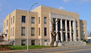
Dunklin County is a county located in the Bootheel of the state of Missouri. Based on the 2010 census, the population was 31,953. The
largest city and county seat is Kennett. The county was officially organized on February 14, 1845, and is named in honor of Daniel Dunklin, a
Governor of Missouri who died the year before the county was organized.
Dunklin County comprises the Kennett, MO Micropolitan Statistical Area.
Etymology - Origin of Dunklin County Name
Named for Daniel Dunklin, governor of Missouri.
Demographics:
County QuickFacts: CensusBureau Quick Facts
History of Dunklin County
Created February 14, 1845. Stoddard County was divided by a line running on the parallel of 36 30 and that part of the county south of the line was called Dunklin County. Its boundaries were fixed as follows: Beginning in the middle of the main channel of the St. Francois River at a point where the state line between Missouri and Arkansas, in latitude 36 30, leaves said river; thence due east to the western boundary of New Madrid County; thence south with said line to the southern boundary of the state; thence west on said line to middle of main channel of St. Francois River; thence up the middle of the river to the place of beginning. In 1853 the north line of the county was moved nine miles north. The territory included in this county, with the exception of the nine mile strip, was a part of the territory originally left in Arkansas, but was added to the territory of Missouri through the efforts of J. Hardeman Walker. The county was named for Honorable Daniel Dunklin, governor of Missouri from 1832-1836. He was born in 1790 near Greenville, South Carolina, and came to Potosi, Missouri in 1810. He was elected to the first constitutional convention of Missouri in 1820. In 1828 he was elected lieutenant-governor, and at the close of this term was elected governor. He resigned in 1836 to accept the position of surveyor general of Missouri, Arkansas, and Illinois under President Jackson. He traced the boundaries of Missouri and Arkansas, and it is probably because of this connection with the people of Dunklin County that the county was named for him. (Douglass I 322, Missouri Revised Statutes 1845)
Source: Hamlett, Mayme L. "Place Names Of Six Southeast Counties Of Missouri." M.A. thesis., University of Missouri-Columbia, 1938.
Geography: Land and Water
As reported by the Census Bureau, the county has a total area of 547 square miles (1,420 km2), of which 541 square miles (1,400 km2) is
land and 6.1 square miles (16 km2) (1.1%) is water. The lowest point in the state of Missouri is located on the St. Francis River in Buffalo
Township in Dunklin County, where it flows out of Missouri and into Arkansas.
Neighboring Counties
Bordering counties are as follows:
- Stoddard County (north)
- New Madrid County (northeast)
- Pemiscot County (east)
- Mississippi County, Arkansas (southeast)
- Craighead County, Arkansas (south)
- Greene County, Arkansas (southwest)
- Clay County, Arkansas (west)
- Butler County (northwest)
Education
Of adults 25 years of age and older in Dunklin County, 63.7% possesses a high school diploma or higher while 9.1% hold a bachelor's degree or higher as their highest educational attainment.
Public schools
Campbell R-II School District - Campbell
Clarkton C-4 School District - Clarkton
Holcomb R-III School District - Holcomb
Kennett School District 39 - Kennett
Malden R-I School District - Malden
Senath-Hornersville C-8 School District - Senath
Southland C-9 School District - Cardwell
Private schools
Kennett Christian Academy - Kennett - (K-12) - Assemblies of God/Pentecostal
St. Teresa School - Campbell - (PK-08) - Roman Catholic
Alternative and vocational schools
Bootheel State School - Clarkton - (K-12) - A school for handicapped students and/or those with special needs.
Diagnostic Center - Kennett - (PK-12) - Special Education
Kennett Area Vocational School - Kennett - (09-12) - Vocational/technical


Click Image to Enlarge
