


Click Image to Enlarge
Missouri Counties
Missouri has one hundred and fourteen counties and one independent city. St. Louis City is separate from St. Louis County and is referred to as a "city not within a county." Following the Louisiana Purchase and the admittance of Louisiana into the United States in 1812, five counties were formed out of the Missouri Territory at the first general assembly. Most subsequent counties were apportioned from these five original counties.Jefferson County, Missouri
Jefferson County Education, Geography, and History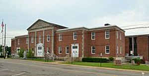
Jefferson County is a county located in the eastern portion of the state of Missouri. Based on the 2010 census, the population was 218,733, making it the sixth-most populous county in Missouri. Its county seat is Hillsboro. The county was organized in 1818 and named in honor of former President Thomas Jefferson.
Etymology - Origin of Jefferson County Name
Named for Thomas Jefferson, 3rd President of the United States.
Demographics:
County QuickFacts: CensusBureau Quick Facts
History of Jefferson County
The boundaries of Jefferson County are as follows; St. Louis County and the Meramec River on the north, the Mississippi River on the east, Ste. Genevieve, St. Francois, and Washington Counties on the south, and Franklin County on the west. The first settler was John Hilderbrand, of French descent, who founded the Meramec colony on Saline Creek in 1774. Meramec, so named because of its proximity to the Meramec River, is remembered today only as the first settlement in what became Jefferson County. In the days of Spanish ownership and domination, Jefferson County was a part of Ste. Genevieve District. After 1803 when the United States purchased the Louisiana Territory, the districts were called counties and the boundaries were changed so that part of Jefferson County north of Plattin Creek was in St. Louis County and that south of the creek remained in Ste. Genevieve County. The county was organized by an act of the Legislature of the Territory of Missouri on December 8, 1818, and was named for Thomas Jefferson (1743-1826), the third president of the United States, who was responsible for the Louisiana Purchase which added the Territory of Missouri to the Union. When Jefferson County was formed it was divided into three townships: Joachim on the east, Big River on the west, and Plattin on the south. In 1821 Big River Township was divided and the northern part was called Meramec Township; in 1834 Valle Township was formed from the western part of Plattin Township, and Rock Township from the northern part of Joachim Township. Since the records at the county seat and at Jefferson City had all been destroyed by fire, the actual township lines were the subject of dispute. In 1838 the boundaries of the townships were again defined and have remained as defined then, except that Central Township was carved from the center of the county in 1842. (COUNTY ATLAS (1876); Parker (1867); S.W. IMMIGRATION (1881); COUNTY HIST. (1888), 369 ff.; ENCY. MISSOURI (1901); Eaton (1916), 179)
Source: Welty, Ruth. "Place Names of St. Louis And Jefferson County." M.A. thesis., University of Missouri-Columbia, 1939.
Geography: Land and Water
As reported by the Census Bureau, the county has a total area of 664 square miles (1,720 km2), of which 657 square miles (1,700 km2) is
land and 7.7 square miles (20 km2) (1.2%) is water. The county's eastern border is the Mississippi River, and on the other side is Illinois.
Neighboring Counties
Bordering counties are as follows:
- St. Louis County (north)
- Monroe County, Illinois (east)
- Ste. Genevieve County (southeast)
- St. Francois County (south)
- Washington County (southwest)
- Franklin County (west)
Education
Public schools
Crystal City School District 47 - Crystal City
De Soto School District 73 - De Soto
Dunklin R-V School District - Herculaneum
Festus R-VI School District - Festus
Fox C-6 School District - Arnold
Grandview R-II School District - Hillsboro
Hillsboro R-III School District - Hillsboro
Jefferson County R-VII School District - Festus
Northwest R-I School District - High Ridge
Sunrise R-IX School District - De Soto
Windsor C-1 School District - Imperial
Private schools
Christian Outreach School (K-12) - Hillsboro - Nondenominational Christian
People's Christian Academy (K-12) - Arnold - Assembly of God/Pentecostal
St. Pius X High School (09-12) - Festus - Roman Catholic
Twin City Christian Academy (PK-12) - Festus - Baptist
Good Shepherd Catholic School - (K-08) - Hillsboro - Roman Catholic
Holy Child Elementary & Middle School - Arnold - (K-08) - Roman Catholic
Manna Christian Academy - De Soto - (K-12) - Southern Baptist
Our Lady's Catholic School - Festus - (K-08) - Roman Catholic
Our Lady Queen of Peace School - House Springs - (K-08) - Roman Catholic
Sacred Heart Catholic School - Festus - (K-08) - Roman Catholic
St. Anthony's Catholic School - High Ridge - (K-08) - Roman Catholic
St. Joseph's Catholic School - Imperial - (K-08) - Roman Catholic
St. Johns Lutheran School - Arnold - (PK-08) - Lutheran
St. Johns School - Imperial - (K-08) - Nondenominational Christianity
St. Rose of Lima Catholic School - De Soto - (K-08) - Roman Catholic
Post-secondary
ITT Technical Institute - Arnold
Jefferson College - Hillsboro A public, two-year community college.


Click Image to Enlarge
