


Click Image to Enlarge
Missouri Counties
Missouri has one hundred and fourteen counties and one independent city. St. Louis City is separate from St. Louis County and is referred to as a "city not within a county." Following the Louisiana Purchase and the admittance of Louisiana into the United States in 1812, five counties were formed out of the Missouri Territory at the first general assembly. Most subsequent counties were apportioned from these five original counties.Ray County, Missouri
Ray County Education, Geography, and History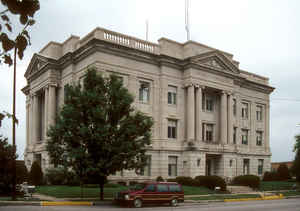
Ray County is a county located in the northwestern portion of the state of Missouri. Based on the 2010 census, the population was 23,494.
Its county seat is Richmond. The county was organized November 16, 1820 and named for John Ray, a Missouri state legislator and member of the
first state Constitutional Convention.
Ray County is part of the Kansas City, MO-KS Metropolitan Statistical Area.
Etymology - Origin of Ray County Name
Named for John Ray, member of the first state constitutional convention.
Demographics:
County QuickFacts: CensusBureau Quick Facts
History of Ray County
This county was originally a part of Howard County. See Lafayette County. It was organized as Ray in 1820 and named in honor of John Ray, a landowner, and one of the delegates to the convention which met in St. Louis in June, 1820, for the purpose of framing a state constitution for Missouri. At the time of the naming of Ray it included all the present counties north of its present boundary, and also present Clay County and all counties lying north of Clay. In 1822 Clay County was organized. It included its present territory and all counties north of it to the Iowa line. In 1836 all territory north of the present north boundary of Ray was set apart as Caldwell County. The county is bounded today by Caldwell County on the north, Carroll on the east, a part of Lafayette and Jackson on the south, and Clay and a part of Clinton on the west. (Williams 1915, Vol. I, 607; HIST. RAY 1881, 215; Ewing, thesis, 56, 66)
Source: Atchison, Anne. "Place Names Of Five West Central Counties Of Missouri." M.A. thesis., University of Missouri-Columbia, 1937.
Geography: Land and Water
As reported by the Census Bureau, the county has a total area of 574 square miles (1,490 km2), of which 569 square miles (1,470 km2) is
land and 5.4 square miles (14 km2) (0.9%) is water.
Neighboring Counties
Bordering counties are as follows:
- Caldwell County (north)
- Carroll County (east)
- Lafayette County (south)
- Jackson County (southwest)
- Clay County (west)
- Clinton County (northwest)
Education
Public schools
Hardin-Central C-2 School District - Hardin
Lawson R-XIV School District - Lawson
Orrick R-XI School District - Orrick
Richmond R-XVI School District - Richmond


Click Image to Enlarge
