


Click Image to Enlarge
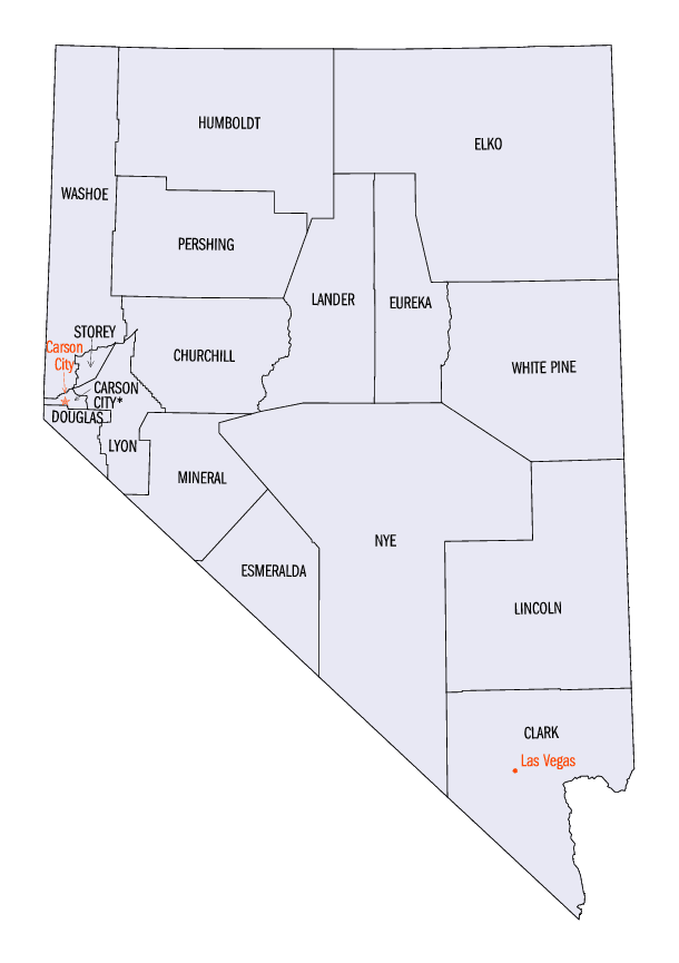
Nevada Counties
There are sixteen counties and one independent city in the state of Nevada. On November 25, 1861, the first Nevada Territorial Legislature established nine counties. Nevada was admitted to the Union on October 31, 1864 with eleven counties. In 1969, Ormsby County and Carson City were consolidated into a single municipal government known as Carson City.Clark County, Nevada
Clark County Education, Geography, and History
Clark County is a county located in southern Nevada. Based on the 2010 census, the population was 1,951,269, with an estimated population of 2,000,759 in 2012. The county was formed by the Nevada Legislature by splitting off a portion of Lincoln County on February 5, 1909, and came into existence on July 1, 1909. Las Vegas, Nevada's most populous city, has been the county seat since the county was established. The county was named for William Andrews Clark, Sr. (January 8, 1839 - March 2, 1925) was an American politician and entrepreneur, involved with mining, banking and railroads.
Clark County is coextensive with the Las Vegas-Paradise, NV Metropolitan Statistical Area, a metropolitan statistical area designated by the Office of Management and Budget and used by the United States Census Bureau and other agencies for statistical purposes
Etymology - Origin of Clark County Name
The county was named for William Andrews Clark, a Montana copper magnate and US Senator. Clark was largely responsible for the construction of the Los Angeles and Salt Lake Railroad through the area, a factor heavily contributing to the region's early development.
Demographics:
County QuickFacts: CensusBureau Quick Facts
Clark County History
Created from southern Lincoln County, February 5, 1908. Seat: Las Vegas. Much of the county was originally part of
Pah-Ute County, Arizona Territory before Nevada became a state. The county was named for William Andrews Clark, a
Montana copper magnate and United States Senator. Clark was largely responsible for the construction of the Los Angeles
and Salt Lake Railroad through the area, a factor heavily contributing to the region's early development.
Geography: Land and Water
As reported by the Census Bureau, the county has a total area of 8,091 square miles (20,960 km2). Land covers
7,910 sq mi (20,500 km2) and water covers 180 sq mi (470 km2) (2.23%).
The Colorado River forms the county's southeastern boundary, with Hoover Dam forming Lake Mead along much of its
length. Las Vegas is frequently, yet incorrectly, labeled a valley. By definition, Greater Las Vegas is a land basin
or bowl, surrounded by four mountain ranges, with nearby Mount Charleston being the highest elevation at 11,918 ft,
located to the northwest. Other than the forests on Mount Charleston, the geography in Clark County is a desert.
Creosote bushes are the main native vegetation, and the mountains are mostly rocky with little vegetation.
Neighboring Counties
Bordering counties are as follows:
- Lincoln County, Nevada - north
- Nye County, Nevada - west
- Inyo County, California - southwest
- San Bernardino County, California - south
- Mohave County, Arizona - east
Education
The Clark County School District serves all of Clark County with 228 elementary schools, 59 middle schools, and 54 high schools being the
fifth largest in the country. Current enrollment of students as of 2013 was 312,892.
Colleges serving the area are University of Nevada, Las Vegas (UNLV), College of Southern Nevada, and Nevada State College.


Click Image to Enlarge
