

Click Image to Enlarge
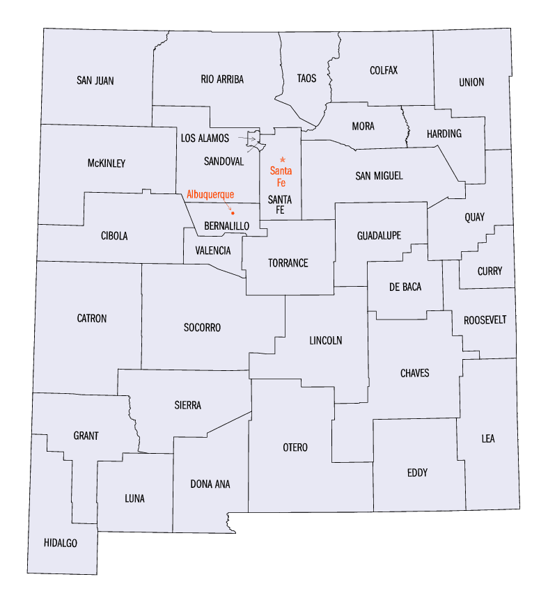
New Mexico Counties
There is thirty-three counties in the state of New Mexico. There were originally nine counties formed in 1852. Santa Ana County, New Mexico Territory, one of the nine original counties, was annexed in 1876 to Bernalillo County, New Mexico.Colfax County, New Mexico
Colfax County Education, Geography, and History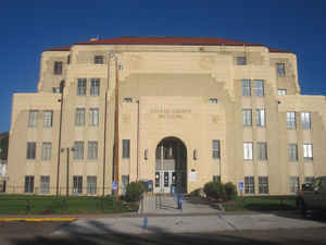
Colfax County is a county located in the state of New Mexico. Based on the 2010 census, the population was 13,750. Its county seat is Raton. It is south from the Colorado state line. This county was named for Schuyler Colfax (1823-1885), seventeenth Vice President of the United States under US President Ulysses S. Grant.
Etymology - Origin of Colfax County Name
Named in honor of Vice-President-Elect Schuyler Colfax.
Demographics:
County QuickFacts: CensusBureau Quick Facts
Colfax County History
Colfax County was created 25 January 1869. The county seat is Raton. Colfax was the name of Vice-president of the USA, Schuyler Colfax, in 1869. Ranching, farming, mining, and tourism are the mainstay of Colfax County.
Colfax County was originally part of Taos County, one of the original nine counties created by the New Mexico Territory in 1852. In 1859,
the eastern part of Taos County, including all of the territory of Colfax County, was split off to form Mora County. Colfax County was
established on January 25, 1869 from the northern part of Mora County. The original county seat was the gold mining town of Elizabethtown.
By 1872, when the gold rush in Elizabethtown had died down, the county seat was moved to Cimarron. Cimarron was on the stage coach route along
the Mountain Branch of the Santa Fe Trail, and was the headquarters of the Maxwell Land Grant. The Colfax County Courthouse in Cimarron is a
contributing structure in the Cimarron Historic District, and is still in use as a Masonic lodge.
In 1881, the county seat was moved from Cimarron to Springer, located on the former Atchison, Topeka, and Santa Fe Railroad, since 1996 part
of the Burlington Northern Railroad. The Colfax County Courthouse in Springer was the site of one of the last important shoot-outs in the
Colfax County War. This former courthouse, which is on the National Register of Historic Places is now the home of a museum devoted to the
Santa Fe Trail.
The eastern portions of Colfax, Mora, and San Miguel counties were severed to form Union County in 1893.
After a referendum and a bitter legislative fight, the county seat moved from Springer to Raton in 1897. Raton was an important coal-mining
town, and was also a railroad center. The citizens of Raton raised $8000 to pay one third of the costs of a new courthouse. That courthouse
was replaced in 1932 by the current Colfax County Courthouse (Raton, New Mexico), an art-deco WPA structure that also is on the National
Register of Historic Places.
Geography: Land and Water
As reported by the Census Bureau, the county has a total area of 3,768 square miles (9,760 km2), of which 3,758 square miles (9,730 km2)
is land and 10 square miles (26 km2) (0.3%) is water.
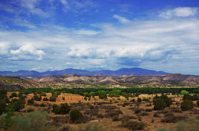
A large portion of the County lies in the Sangre de Cristo Mountains. Geography ranges from prairies, to pinon forests, to alpine meadows.
Neighboring Counties
Bordering counties are as follows:
- Taos County - west
- Mora County - south
- Harding County - south
- Union County - east
- Las Animas County, Colorado - north
- Costilla County, Colorado - northwest
Education


Click Image to Enlarge
