

Click Image to Enlarge
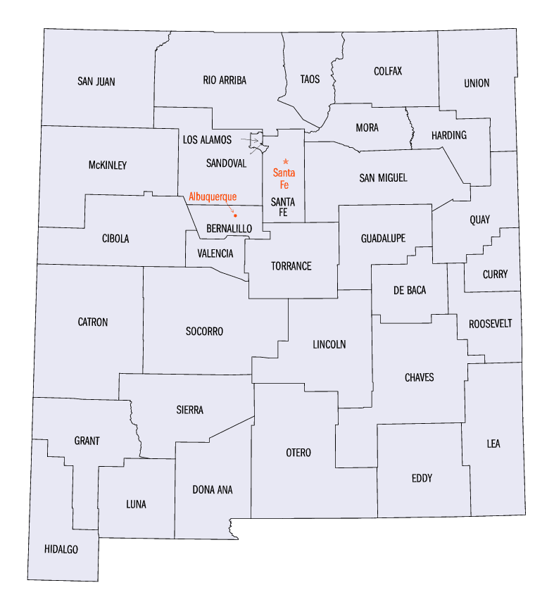
New Mexico Counties
There is thirty-three counties in the state of New Mexico. There were originally nine counties formed in 1852. Santa Ana County, New Mexico Territory, one of the nine original counties, was annexed in 1876 to Bernalillo County, New Mexico.Socorro County, New Mexico
Socorro County Education, Geography, and History
Socorro County is a county located in the state of New Mexico. Based on the 2010 census, the population was 17,866. The county seat is Socorro. The county was formed in 1852 as one of the original nine counties of New Mexico Territory. Socorro was originally the name given to a Native American village (see: Puebloan peoples) by Don Juan de Oñate in 1598. Having received vitally needed food and assistance from the native population, Oñate named the pueblo Socorro ("succor" in English).
Etymology - Origin of Socorro County Name
It was named by Don Juan de Onate. The name means "helpful".
Demographics:
County QuickFacts: CensusBureau Quick Facts
Socorro County History
Socorro County was established 1 July 1850. The county seat is Socorro. It was named by Don Juan de Onate. The name means "helpful". This county is prime ranching territory. It also has some of the biggest buck deer in New Mexico. It was also the county in which the first atomic bomb was exploded.
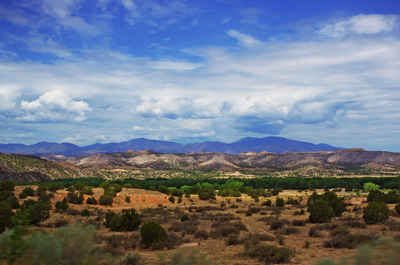
The history of Socorro County is intimately linked with the rich history of the surrounding area. Basham noted in his report documenting the archeological history of the Cibola National Forest's Magdalena Ranger District, which is located almost entirely within Socorro County, that 'the heritage resources on the district are diverse and representative of nearly every prominent human evolutionary event known to anthropology. Evidence for human use of district lands date back 14,000 years to the Paleoindian period providing glimpses into the peopling of the New World and megafaunal extinction.' Much of the now Magdalena Ranger District were a province of the Apache. Bands of Apache effectively controlled the Magdalena-Datil region from the seventeenth century until they were defeated in the Apache Wars in the late nineteenth century. Outlaw renegades Butch Cassidy and the Wild Bunch and notorious Apaches like Cochise and Geronimo have ties to Socorro County's San Mateo Mountains. Vicks Peak was named after Victorio, ' Mimbre' Apache leader whose territory included much of the south and southwest New Mexico.'? Famous for defying relocation orders in 1879 and leading his warriors on a two-year reign of terror before he was killed,? Victorio is at least as highly regarded as Geronimo or Cochise among Apaches. Perhaps most famous outlaw was the Apache Kid whose supposed grave lies within the Apache Kid Wilderness. Stories of depredations by the Apache Kid, and of his demise, became so common and dramatic that in southwestern folklore they may be exceeded only by tales of lost Spanish gold. Native Americans lingered in the San Mateos well into the 1900s. We know this by an essay written by Aldo Leopold in 1919 where he documents stumbling upon the remains of a recently abandoned Indian hunting camp.
Geography: Land and Water
As reported by the Census Bureau, the county has a total area of 6,649 square miles (17,220 km2), of which 6,647 square miles (17,220
km2) is land and 2.1 square miles (5.4 km2) (0.03%) is water.
It is the second-largest county in New Mexico by area, after Catron County, New Mexico.
Socorro County ranges in elevation from approximately 4,528 ft (1,380 m) on the banks of the Rio Grande to 10,784 ft (3,287 m) at the top of
South Baldy peak in the Magdalena Mountains. The southern portion of the Rocky Mountains extend into New Mexico and Socorro County. There are
several mountain ranges that spread throughout the county. The Forest Service manages portions of four mountain ranges: the Bear, Datil,
Magdalena, and San Mateo Mountains. Most of the land that comprises these mountains are within the Cibola National Forest. These ranges, as
well as Ladron Peak located in Socorro County, are classified as sky islands.
Neighboring Counties
Bordering counties are as follows:
- Cibola County - northwest
- Valencia County - north
- Torrance County - northeast
- Lincoln County - east
- Sierra County - south
- Catron County - west
Cities and Towns:
Education

County Resources:
Enter County Resources and Information Here

Click Image to Enlarge
