

Click Image to Enlarge
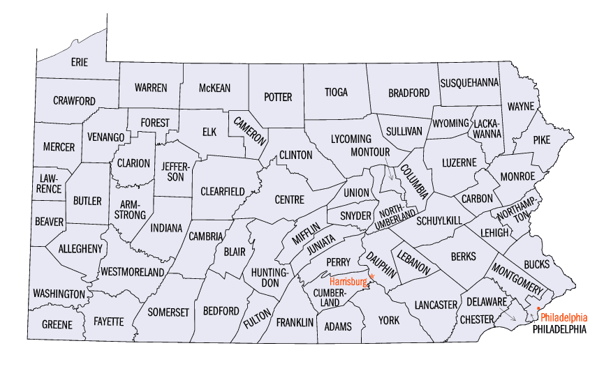
Pennsylvania Counties
There are sixty-seven counties of the Commonwealth of Pennsylvania in the United States of America. The city of Philadelphia is coterminous with Philadelphia County, and governmental functions have been consolidated since 1854.Bradford County, Pennsylvania
Bradford County Education, Geography, and History
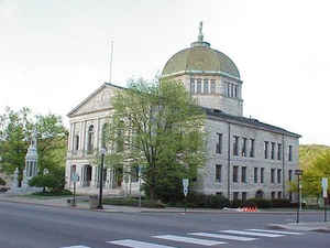
Bradford County is a county located in the state of Pennsylvania. Based on the 2010 census, the population was 62,622. Its county seat is
Towanda. The county was created on February 21, 1810, from parts of Lycoming and Luzerne counties. Originally called Ontario County, it was
reorganized and separated from Lycoming County on October 13, 1812, and renamed Bradford County for William Bradford, who had been a chief
justice of the Pennsylvania Supreme Court and United States Attorney General.
Bradford County comprises the Sayre, PA Micropolitan Statistical Area.
Etymology - Origin of County Name
Originally named Oneida County for the lake of the same name. On March 24, 1812 it was formally renamed for
William Bradford (September 14, 1755 - August 23, 1795), a lawyer and judge from Philadelphia, Pennsylvania, and the
second United States Attorney General in 1794-1795.
Demographics:
County QuickFacts: CensusBureau Quick Facts
County History
Created on February 21, 1810, from
parts of Luzerne and Lycoming Counties and named Oneida County for the lake of
the same name. On March 24, 1812 it was formally renamed for William Bradford,
second Attorney General of the United States. Towanda, the county seat, was
incorporated as a borough on March 5, 1828 and named for Towanda Creek.
After the Revolution, veterans of the Sullivan expedition against the Indians
and Dutch immigrants from New York settled the area. French refugees flourished
at Azilium from 1793 to 1804. The county was part of the area plagued by
disputes over land claims based on settlement by people from Connecticut.
Englishman Robert Barclay began coal mining in 1812, which buttressed the
economy and spawned a canal and a railroad. As Barclay's mines were closing, a
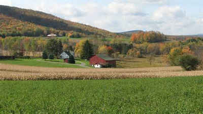
lumber boom began, and it flourished until about 1930. Dairy farming is
presently the backbone of the economy; the county has many small farms. These
cover 46 percent of the land. Athens, Towanda, and Canton were Underground
Railroad stations, and David Wilmot struggled against slavery in Congress with
his many Wilmot Provisos. The myth of the French Queen Marie Antoinette's plan
to flee to French Azilium has provided local color. Also, the history of the
misdeeds of members of a family named Pool once gave rise to a theory that they
had a genetic criminal makeup. This was musician Stephen Foster's home.
Geography: Land and Water
As reported by the Census Bureau, the county has a total area of 1,161 square miles (3,007 km2), of which,
1,151 square miles (2,980 km2) of it is land and 10 square miles (27 km2) of it (0.89%) is water.
Neighboring Counties
Bordering counties are as follows:
- Chemung County, New York (north)
- Tioga County, New York (north)
- Susquehanna County (east)
- Wyoming County (southeast)
- Sullivan County (south)
- Lycoming County (southwest)
- Tioga County (west)
Education
Public school districts
Athens Area School District
Canton Area School District (also in Lycoming and Tioga Counties)
Northeast Bradford School District
Sayre Area School District
Towanda Area School District
Troy Area School District
Wyalusing Area School District (also in Wyoming County)
There are 14 public cyber charter schools in Pennsylvania that are available for free statewide, to children K-12.


Click Image to Enlarge
