

Click Image to Enlarge
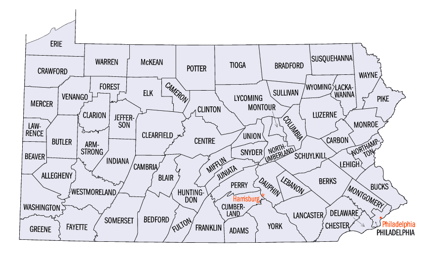
Pennsylvania Counties
There are sixty-seven counties of the Commonwealth of Pennsylvania in the United States of America. The city of Philadelphia is coterminous with Philadelphia County, and governmental functions have been consolidated since 1854.Erie County, Pennsylvania
Erie County Education, Geography, and History
Erie County is a county located in the state of Pennsylvania.
Based on the 2010 census, the population was 280,566.
Its county seat is Erie. The county was created
in 1800 and later organized in 1803. Erie County was
named for Lake Erie.
Erie County comprises the Erie, PA Metropolitan Statistical Area.
Etymology - Origin of Erie County Name
Named for Lake Erie, which in turn had been named for the Indians of the same name.
Demographics:
County QuickFacts: CensusBureau Quick Facts
Erie County History
Created on March 12, 1800, from part of Allegheny County and named
for Lake Erie, which in turn had been named for the Indians of the same
name. It was attached to Crawford County until 1803. Erie, the county
seat, was so named because it was a port on Lake Erie. Laid out in 1795,
it was incorporated as a borough on May 29, 1805 and as a city on April
14, 1851. The county adopted a home rule charter in November 1976.
Pennsylvania purchased this territory from the United States government
in 1792. The city of Erie began to grow during the War of 1812. It was
the point from which Commodore Perry's fleet sailed to fight the Battle
of Lake Erie in 1813. Abundant running water led to the development
of many sawmills and gristmills. There was a brief oil boom in the 1860s,
and in the middle of the century Erie was the freshwater fishing capital
of America. The Erie Extension Canal was opened in 1844, and railroads
were introduced in 1864. As a Great Lakes port, Erie has declined since
1900. Once important for manufacturing such items as General Electric's
locomotives and Hammermill Paper, Erie still turns out electrical products.
Grapes grow well along the lakeshore; a significant wine making industry
developed. Erie ranks fifth among the counties in value of crops and
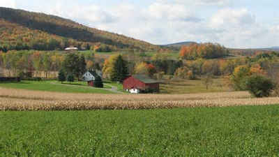
tenth in value of livestock product sales. Farms cover 36 percent of
the landed area.
Geography: Land and Water
As reported by the Census Bureau, the county has a total area of 1,558 square miles (4,036 km2), of which, 802 square miles (2,077 km2) of it is land and 756 square miles (1,959 km2) of it (48.54%) is water. There are only two cities in Erie County; the City of Erie and the City of Corry.
The Erie Triangle is a roughly 300-square-mile tract of American land that was the subject of several competing colonial-era claims and which was eventually acquired by the U.S. federal government and sold to Pennsylvania so that the state would have access to a freshwater port on Lake Erie Erie County serves as a connecting crossroads between the east and the west of the Great Lakes region.
The land surface is of variable
maturity and strongly reflects the influence of recent glaciation. The
basic surface features, i.e. the lake plain giving way southward to
an escarpment topped by a rolling upland,
can be traced to the influence of bedrock of different hardnesses.
Neighboring Counties
Bordering counties are as follows:
- Northeast by Chautauqua County, New York
- East by Warren County
- South by Crawford County
- West by Ashtabula County, Ohio.
- North of the county is Lake Erie, with the nearest landmass
beyond it being the province of Ontario, Canada. This position on
the water makes Erie County the only county in Pennsylvania to share
a border with Canada, which is located on the far shore of
the lake.
Education
Public school districts
Corry Area School District
Erie City School District
Fairview School District
Fort LeBoeuf School District
General McLane School District
Girard School District
Harbor Creek School District
Iroquois School District
Millcreek Township School District
North East School District
Northwestern School District
Union City Area School District
Wattsburg Area School District


Click Image to Enlarge
