

Click Image to Enlarge
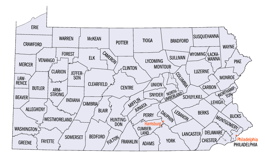
Pennsylvania Counties
There are sixty-seven counties of the Commonwealth of Pennsylvania in the United States of America. The city of Philadelphia is coterminous with Philadelphia County, and governmental functions have been consolidated since 1854.Lancaster County, Pennsylvania
Lancaster County Education, Geography, and History
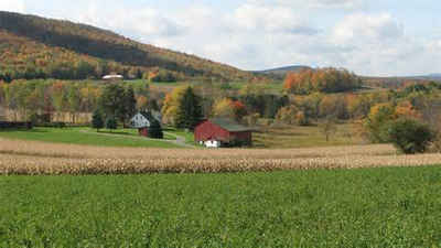
Lancaster County , (Pennsylvania German: Lengeschder Kaundi) sometimes nicknamed the Garden Spot of America or Pennsylvania Dutch Country, is
a county located in the south central part of the Commonwealth of Pennsylvania. Based on the 2010 census, the population was 519,445. Its county
seat is Lancaster.
Lancaster County comprises the Lancaster, Pennsylvania Metropolitan Statistical Area.
Etymology - Origin of Lancaster County Name
Named for Lancashire, England.
Demographics:
County QuickFacts: CensusBureau Quick Facts
Lancaster County History
Created on May 10, 1729 from part of
Chester County and named for Lancashire, England. Lancaster, the county seat,
also named for its English counterpart, was laid out in 1730. It was chartered
as a borough on May 1, 1742 and as a city on March 10, 1818.
The area was rapidly settled after 1709 by a mix of peoples: Swiss Mennonites,
Huguenots, Scotch-Irish, English, Welsh, and Rhineland Germans. This was the
first new county since the original three of 1682. Its rich limestone soil meant
farming had to prosper. Coupled with the charitable humanitarianism of its
religious values there developed a tradition that the poor could find
opportunity here- "the buttermilk way." Before 1776, Lancaster was the largest
inland city in Britain's American colonies. The decade 1800-1810 was stagnant,
but then new enterprises began: gristmills, lime burning, and iron. A turnpike
linked Lancaster to Philadelphia in 1800, and the Columbia and Philadelphia
Railroad opened in 1834. The Conestoga Slackwater Canal facilitated trade with
Baltimore. In the late nineteenth century there was a manufacturing take off
including: cigars, cotton and silk cloth, beer, stoves, watches and clocks, and
farm tools. The county ceased manufacturing iron. In this century, Armstrong
Cork, R.C.A., Raybestos, Sperry-Rand, and Kerr Glass Company prospered, and some
of the garments industry continues. Always Pennsylvania's most prolific
agricultural county, two-thirds of Lancaster County is farmland; animal products
make up over 90 percent of farm cash receipts. Only the high prices paid for
Chester County's mushrooms compete with the cash returns from Lancaster's
harvests.
Geography: Land and Water
Lancaster County has a total area of 984 square miles (2,548 km2). 949 square miles (2,458 km2) of which is land
and 35 square miles (90 km2) of it (3.53%) is water.[
Neighboring Counties
Bordering counties are as follows:
- north by Lebanon County
- northeast by Berks County
- east by Chester County (the southeastern boundary with Chester County is formed by Octoraro Creek).
- south are Cecil and Harford Counties, Maryland (across the Mason-Dixon line).
- west is York County (the boundary is the western shore of the Susquehanna River).
- northwest is Dauphin County (the boundary is formed by Conewago Creek).
Education
The colleges of Lancaster County are Eastern Mennonite University, Elizabethtown College, Franklin & Marshall College, Harrisburg Area
Community College, Lancaster Bible College, Lancaster Theological Seminary, Millersville University of Pennsylvania, Pennsylvania College of
Art and Design, Thaddeus Stevens College of Technology and Lancaster General College of Nursing and Health Sciences.
There are 16 public school districts in the county.


Click Image to Enlarge
