South Carolina Counties
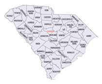
South Carolina is made up of fourty-six counties. They range in size from 392 square miles (1,016 square kilometers) in the case of Calhoun County to 1,358 square miles (3,517 square kilometers) in the case of Charleston County. The least populous county is McCormick County, with only 9,958 residents, while the most populous county is Greenville County, with a population of 395,357, despite the state's most populous city, Columbia, being located in Richland County.Chesterfield County, South Carolina
Chesterfield County Education, Geography, and History

Chesterfield County is a county located in the state of South Carolina. Based on the 2010 census, its population was 46,734. Its county seat is Chesterfield. The county was formed in 1785, but was part of the Cheraws District until 1800, at which time Chesterfield became a district. Under the 1867 state constitution passed during the Reconstruction era, South Carolina districts became counties with home rule. It is located north of the Midlands, on its border with North Carolina.
Etymology - Origin of Chesterfield County Name
Chester is named after Chester, Pennsylvania. Chesterfield is named after Philip Dormer Stanhope, 4th Earl of Chesterfield.
Demographics:
County QuickFacts: CensusBureau Quick Facts
Chesterfield County History
Chesterfield County was named for the English statesman Lord Chesterfield (1694-1773). The county seat is the town of Chesterfield, but the oldest town in the county is Cheraw, which was settled around 1748. The county was formed in 1785, but until 1800 it was part of the larger Cheraws District. Welsh settlers from Pennsylvania and Delaware moved into this region in the mid-eighteenth century, and they were later joined by Scotch-Irish and English. Cheraw was a center for transportation along the Great Pee Dee River, but most of the county is agricultural. General Sherman's troops passed through this area during the Civil War, briefly occupying the towns of Cheraw and Chesterfield. Cheraw State Park, founded in 1934, is the oldest of the state parks. Jazz musician Dizzy Gillespie (1917-1993) was a native of Chesterfield County.
Geography: Land and Water
As reported by the Census Bureau, the county has a total area of 806
square miles (2,087 km2), of which, 799 square miles (2,068 km2) of it is land
and 7 square miles (19 km2) of it (0.89%) is water.
Neighboring Counties
Bordering counties are as follows:
- Anson County, North Carolina - north
- Richmond County, North Carolina - northeast
- Marlboro County, South Carolina - east
- Darlington County, South Carolina - southeast
- Kershaw County, South Carolina - southwest
- Lancaster County, South Carolina - west
- Union County, North Carolina - northwest
Education
The county's youth are provided with an education through the Chesterfield County School District. The South Point Christian School is a private
school located in Pageland and offers Kindergarten through 12th grade.
Northeastern Technical College has branches in Pageland and Cheraw.


