


South Carolina State Almanac: Facts and Figures
Quick Facts, Figures, and Overview of the State of South Carolina
South Carolina is one of the South Atlantic states of the US. South Carolina is bordered to the north by North Carolina; to the south and west by Georgia, located across the Savannah River; and to the east by the Atlantic Ocean. South Carolina encompasses total area of 80,583 square kilometer. South Carolina was named to honor Charles IX of France and then Charles I and Charles II of England. Carolina is rooted in Latin and comes from the word Caroliinus. This word is derived from the name Carolus, translated as "Charles."
Once primarily agricultural, South Carolina today has many large textile and other mills that produce several times the output of its farms in cash value. Charleston makes asbestos, wood, pulp, steel products, chemicals, machinery, and apparel.
Farms have become fewer but larger in recent years. South Carolina ranks second in peach production after California. Other top agricultural commodities
include broilers (31.5% of total state farm receipts), turkeys, greenhouse products, cattle and calves, and corn. One of only two commercial tea plantations
in America is 20 mi south of Charleston on Wadmalaw Island.
South Carolina Almanac: Facts on South Carolina |
|
|---|---|
| Official Name | South Carolina |
| Capital | Columbia |
| Nicknames | Palmetto State ...and more |
| Motto | Animis Opibusque Parati (Prepared in mind and resources) Dum Spiro Spero (While I breathe, I hope) |
| Location Region |
34.03923 N, 080.88634 W Southern South Atlantic Appalachia |
| Constitution Ratified | 1895 |
| Statehood | May 23, 1788 8th state |
| Population | 4,679,230 (2010) 133.24 sq. mi. 26th |
| Largest City (by population) |
10 largest cities (2010 est.):Columbia, 129,272; Charleston, 120,083; North Charleston, 97,471; Rock Hill, 66,154; ; Greenville, 58,409; Sumter, 40,524; Florence 37,056, Spartanburg, 37,013; Goose Creek, 35,938; Aiken, 29,524 |
| Bordering States | North: North Carolina East and South East: Atlantic Ocean South West and West: Georgia (Savannah River forms almost all of the boundary with Georgia, and the Chattooga River forms most of the rest) Coastline: 187 mi. |
| Major Industry | farming (tobacco, soybeans), textiles, manufacturing chemicals, processed foods, machinery, electronics, paper products, tourism |
| Major Rivers | Santee River, Edisto River, Savannah River |
| Major Lakes | Lake Marion, Lake Moultrie, Lake Murray, Hartwell Lake |
| South Carolina Counties | 46 Counties in South Carolina |
| Largest County (by population) |
Greenville County 451,225 (2010) 792 sq. mi. |
| Largest County (by area) |
Horry County 1,134 sq mi. |
| State forests | 4 |
| State parks | 47 (80,000+ ac.) |
| Electoral Votes | 8 |
| US Congress | 2 Senators; 6 Representatives |
| Time Zone | Eastern Standard Time |
| Zip Codes | NANPA |
| State Quick Facts | Census Bureau Quick Facts |
South Carolina Climate and Weather |
||
|---|---|---|
| South Carolina's climate is mild and humid.
Its long coast lies near the Gulf Stream, which keeps coastal areas warmer in winter and cooler in summer than the interior. The mountains in the
northwest help protect the rest of the state from cold air, but the higher elevations are usually cooler in summer and colder in winter than the
rest of the state. January temperatures are mild, with some days below freezing along the coast, but most range 37-59 F/3-14 C. Expect temperatures to run 53-76 F/11-24 C along the coast in April, 61-83 F/16-27 C in May. Some severe thunderstorms or tornadoes can occur in spring. Visitors will find pleasant conditions at the beaches through the fall, though summers are hot (high 80s F/30 C to above 90 F/32+ C) and humid. Humidity at 50%-60% in high heat can be quite exhausting, so if you visit in the warm-weather months, pace yourself. Fall can be a pleasant time to visit. The humidity during these months is generally fairly comfortable and temperatures are in the 55-84 F/12-28 C range. Indian summers can last through November, with dry days and temperatures from the low 40s F/5 C to the mid 60s F/18 C. |
||
| Highest Temperature | 111 degrees June 28, 1954 - Camden |
|
| Lowest Temperature | -19 degrees January 21, 1985 - Caesar's Head |
|
| Avg. Temp: High - Low |
91.9 degrees - 31.2 degrees | |
South Carolina Points of Interest |
||
|
As an aggressive
and resilient player in both America's past and present, this somewhat small state is renown for its antebellum homes, historical sites
and southern style, especially in the aesthetically pleasing harbor city of Charleston. Add hundreds of coastal islands and beaches, over 300 golf courses, wilderness areas, watersports of all description, and some the country's most popular NASCAR events, and South Carolina is understandably a mecca for travelers throughout the year. Other points of interest include Fort Sumter National Monument, Fort Moultrie, Fort Johnson, and aircraft carrier USS Yorktown in Charleston Harbor; the Middleton, Magnolia, and Cypress Gardens in Charleston; Cowpens National Battlefield; the Hilton Head resorts; and the Riverbanks Zoo and Botanical Garden in Columbia. |
||
South Carolina Highest, Lowest, and Mean Elevations (Feet) |
||
| Mean Elevation: 350 feet | ||
|
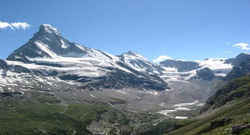
Highest Point: Sassafras Mountain: 3,560 feet
|
||
| Lowest Point: | Atlantic Ocean Sea level |
|
South Carolina Land Area (Square Miles) |
||
| Geographic Center | In Richland County, 13 mi. SE of Columbia Longitude: 80°52.4'W Latitude: 33°49.8'N |
|
| Total Area | 32,020.20 sq. mi. 40th |
|
| Land Area | 30,109.47 sq. mi. | |
| Water Area | 1,910.73 sq. mi. 5.96% |
|
| Forested Land Area | 65.7% | |
| Dimensions (Length - Width) |
260 miles - 200 miles | |
 Pickens County, northwest
South Carolina on North Carolina border 30 miles northwest of Greenville. The summit, owned by the Duke Energy Company, is open to the public without
restriction (other than you have to walk 100 yards up a paved trail). It straddles the North Carolina border.
Pickens County, northwest
South Carolina on North Carolina border 30 miles northwest of Greenville. The summit, owned by the Duke Energy Company, is open to the public without
restriction (other than you have to walk 100 yards up a paved trail). It straddles the North Carolina border.Abbeville, Aiken, Allendale, Anderson, Bamberg, Barnwell, Beaufort, Berkeley, Calhoun, Charleston, Cherokee, Chester, Chesterfield, Clarendon, Colleton, Darlington, Dillon, Dorchester, Edgefield, Fairfield, Florence, Georgetown, Greenville, Greenwood, Hampton, Horry, Jasper, Kershaw, Lancaster, Laurens, Lee, Lexington, Marion, Marlboro, McCormick, Newberry, Oconee, Orangeburg, Pickens, Richland, Saluda, Spartanburg, Sumter, Union, Williamsburg, York

