South Carolina Counties
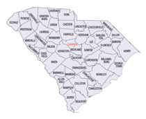
South Carolina is made up of fourty-six counties. They range in size from 392 square miles (1,016 square kilometers) in the case of Calhoun County to 1,358 square miles (3,517 square kilometers) in the case of Charleston County. The least populous county is McCormick County, with only 9,958 residents, while the most populous county is Greenville County, with a population of 395,357, despite the state's most populous city, Columbia, being located in Richland County.Edgefield County, South Carolina
Edgefield County Education, Geography, and History

Edgefield County is a county located on the western border of the state of South Carolina. Based on the 2010 census, its population was
26,985. Edgefield District was created in 1785, and it is bordered on the west by the Savannah River. It was formed from the southern section
of the former Ninety-Six District when it was divided into smaller districts or counties by an act of the state legislature. Parts of the
district were later used in the formation of other neighboring counties, specifically: Aiken in 1871; Saluda in 1895; Greenwood in 1897; and,
McCormick in 1916. Its county seat is Edgefield.
Edgefield County has as part of its western border the Savannah River; across the river is Augusta, Georgia. Edgefield is part of the
Augusta-Richmond County, GA-SC Metropolitan Statistical Area.
Etymology - Origin of Edgefield County Name
The origin of the name Edgefield is not clear, although it is usually described as "fanciful." Also, Edgefield may be so named because it was located on the edge of the state, between the Savannah River and unsettled lands.
Demographics:
County QuickFacts: CensusBureau Quick Facts
Edgefield County History
The origin of the name Edgefield is not clear, although it is usually described as "fanciful." The county was formed in 1785 as part of Ninety Six District; parts of Edgefield later went to form Aiken (1871), Saluda (1895), Greenwood (1897), and McCormick (1916) counties. This part of the upcountry, settled in the late eighteenth century, was the site of several Revolutionary War skirmishes. Although primarily agricultural, Edgefield County developed a thriving pottery industry in the nineteenth century; the old alkaline-glazed Edgefield pottery is highly sought after today. The larger Edgefield County was the home of ten South Carolina governors, including Francis W. Pickens (1805-1869), Benjamin R. Tillman (1847-1918), and Strom Thurmond. Confederate General Martin Witherspoon Gary (1831-1881) was also a resident of Edgefield County.
Geography: Land and Water
As reported by the Census Bureau, the county has a total area of 507 square miles (1,312 km2), of which, 502
square miles (1,300 km2) of it is land and 5 square miles (12 km2) of it (0.92%) is water.
Neighboring Counties
Bordering counties are as follows:
- Saluda County, South Carolina - northeast
- Aiken County, South Carolina - east
- Richmond County, Georgia - southwest
- Columbia County, Georgia - southwest
- McCormick County, South Carolina - west
- Greenwood County, South Carolina - northwest
Education


