South Carolina Counties
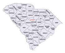
South Carolina is made up of fourty-six counties. They range in size from 392 square miles (1,016 square kilometers) in the case of Calhoun County to 1,358 square miles (3,517 square kilometers) in the case of Charleston County. The least populous county is McCormick County, with only 9,958 residents, while the most populous county is Greenville County, with a population of 395,357, despite the state's most populous city, Columbia, being located in Richland County.Georgetown County, South Carolina
Georgetown County Education, Geography, and History

Georgetown County is a county located in the state of South Carolina. Based on the 2010 census, the population was 60,158. Its county seat
is Georgetown. The county was founded in 1769. It is named for George III of the United Kingdom.
Georgetown County comprises the Georgetown, SC Micropolitan Statistical Area, which is also included in the Myrtle Beach-Conway, SC-NC
Combined Statistical Area.
Etymology - Origin of Georgetown County Name
Georgetown is named for George II of Great Britain.
Demographics:
County QuickFacts: CensusBureau Quick Facts
Georgetown County History
Georgetown County and its county seat were named for King George II of England. Spanish explorers are believed to have visited this coastal area in 1526, but no permanent settlement was established. English planters and their African slaves moved into the region in the early eighteenth century, building large rice and indigo plantations. The town of Georgetown, which was established around 1730, was a busy port serving the surrounding plantations. Georgetown District was first named in 1769 and in 1785 the district was divided into four counties: Liberty (which became Marion District in 1800), Kingston (which became Horry District in 1801), Williamsburg (which became a separate district in 1804), and Winyah (which was renamed Georgetown in 1800). Many famous South Carolinians were residents of Georgetown County, including Thomas Lynch, Jr. (1749-1779), a signer of the Declaration of Independence; Joel Roberts Poinsett (1779-1851), US Congressman, Secretary of War, and Ambassador to Mexico, who introduced the poinsettia to the US; and Joseph Hayne Rainey (1832-1887), the first African-American elected to the US House of Representatives.
Geography: Land and Water
As reported by the Census Bureau, the county has a total area of 1,035 square miles (2,681 km2), of which, 815 square miles (2,110 km2) of it is land and 220 square miles (570 km2) of it (21.27%) is water.
Georgetown County has several rivers, including the Great Pee Dee River, the Waccamaw River, Black River, and Sampit River, all of which
flow into Winyah Bay. The Santee River, which forms the southern boundary of the county, empties directly into the Atlantic. The Intracoastal
Waterway crosses the county and Winyah Bay. The rivers and the bay have had a decisive effect on human development of the area, especially as
the city of Georgetown has an excellent seaport and harbor. Georgetown County is a diverse county with four distinct areas.
Neighboring Counties
Bordering counties are as follows:
- Marion County, South Carolina - north
- Horry County, South Carolina - northeast
- Berkeley County, South Carolina - southwest
- Charleston County, South Carolina - southwest
- Williamsburg County, South Carolina - northwest
Education


