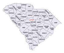
South Carolina Counties
South Carolina is made up of fourty-six counties. They range in size from 392 square miles (1,016 square kilometers) in the case of Calhoun County to 1,358 square miles (3,517 square kilometers) in the case of Charleston County. The least populous county is McCormick County, with only 9,958 residents, while the most populous county is Greenville County, with a population of 395,357, despite the state's most populous city, Columbia, being located in Richland County.Lexington County, South Carolina
Lexington County Education, Geography, and History

Lexington County is a county located in the state of South Carolina. Based on the 2010 census, the population was 262,391, and the 2014
population estimate was 277,888. Its county seat and largest town is Lexington. The county was created in 1785. Its name commemorates the
Battle of Lexington in the American Revolutionary War.
Lexington County is part of the Columbia, SC Metropolitan Statistical Area.
Etymology - Origin of Lexington County Name
Lexington is name for the Battle of Lexington from the American Revolutionary War.
Demographics:
County QuickFacts: CensusBureau Quick Facts
Lexington County History
Lexington County and its county seat were named for the Battle of Lexington, Massachusetts, the first battle of the American Revolution. This part of the state was designated as Lexington County from 1785 to 1791, then was merged back into the larger Orangeburg District. Lexington was eventually made a separate district in 1804. Small parts of the county later went to form Aiken (1871) and Calhoun (1908) counties. European settlement of this area began around 1718 when the British established a trading post on the Congaree River, which eventually became the town of Granby. Beginning in the 1730s many German, Swiss, and Scotch-Irish immigrants moved into the area and established small farms. Granby was the leading town and county seat for many years, but the growth of Columbia across the Congaree led to Granby's decline, and the county seat was moved to the town of Lexington in 1818. General Sherman's troops shelled the city of Columbia from the Lexington side of the Congaree during the Civil War. In 1930 Lake Murray was created on the Saluda River in Lexington County, covering many of the old farms and creating new recreational opportunities.
Geography: Land and Water
As reported by the Census Bureau, the county has a total area of 758 square miles (1,963 km2), of which, 699
square miles (1,811 km2) of it is land and 59 square miles (152 km2) of it (7.74%) is water.
Neighboring Counties
Bordering counties are as follows:
- Richland County, South Carolina - east
- Orangeburg County, South Carolina - southeast
- Calhoun County, South Carolina - southeast
- Aiken County, South Carolina - southwest
- Saluda County, South Carolina - west
- Newberry County, South Carolina - northwest
Education


