South Carolina Counties
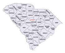
South Carolina is made up of fourty-six counties. They range in size from 392 square miles (1,016 square kilometers) in the case of Calhoun County to 1,358 square miles (3,517 square kilometers) in the case of Charleston County. The least populous county is McCormick County, with only 9,958 residents, while the most populous county is Greenville County, with a population of 395,357, despite the state's most populous city, Columbia, being located in Richland County.Richland County, South Carolina
Richland County Education, Geography, and History

Richland County is a county located in the state of South Carolina. Based on the 2010 census, the population was 384,504, making it the
second-most populous county in South Carolina, behind only Greenville County. The county seat is Columbia, the state capital.
Richland County is part of the Columbia, SC Metropolitan Statistical Area.
Etymology - Origin of Richland County Name
Richland is possibly named for its rich soil.
Demographics:
County QuickFacts: CensusBureau Quick Facts
Richland County History
Richland County was probably named for its "rich land." The county was formed in 1785 as part of the large Camden District. A small part of Richland later went to Kershaw County (1791). In 1786 the state legislature decided to move the capital from Charleston to a more central location. A site was chosen in Richland County, which is in the geographic center of the state, and a new town was laid out. Columbia subsequently became not only the center of government but an important trade and manufacturing center. Cotton from the surrounding plantations was shipped through Columbia and later manufactured into textiles there. Columbia is also known for its educational institutions, particularly the University of South Carolina, which was founded in 1802. General William T. Sherman captured Columbia during the Civil War, and his troops burned the town on February 17, 1865. The US Army returned on more friendly terms in 1917, when Fort Jackson was established. Confederate general, South Carolina Governor, and US Senator Wade Hampton (1818-1902) was a resident of Richland County, and President Woodrow Wilson (1856-1924) lived in Columbia as a boy.
Geography: Land and Water
As reported by the Census Bureau, the county has a total area of 772 square miles (1,999 km2), of which, 756
square miles (1,959 km2) of it is land and 15 square miles (40 km2) of it (1.98%) is water. Richland County is
situated in the center of South Carolina.
Neighboring Counties
Bordering counties are as follows:
- Fairfield County, South Carolina - north
- Kershaw County, South Carolina - northeast
- Sumter County, South Carolina - east
- Calhoun County, South Carolina - south
- Lexington County, South Carolina - west
- Newberry County, South Carolina - Northwest
Education


