


Click Image to Enlarge
Tennessee Counties
There are ninety-five counties in the State of Tennessee. The oldest county is Washington County, founded in 1777. The most recently formed county is Chester County (1879)Cumberland County, Tennessee
Cumberland County Education, Geography, and History
Cumberland County is a county located in the state of Tennessee. Based on the 2010 census, the population was 56,053. Cumberland County was
formed in 1856 from parts of Bledsoe, Roane, Morgan, Fentress, Rhea, Putnam, Overton, and White. Its county seat is Crossville.
Cumberland County comprises the Crossville, TN Micropolitan Statistical Area.
Etymology - Origin of Cumberland County Name
Named in honor of the Cumberland Mountains which Thomas Walker may have named for the Duke of Cumberland, then prime minister of England, ca. 1748.
Demographics:
County QuickFacts: CensusBureau Quick Facts
History of Cumberland County
Created 1855 from White, Bledsoe, Rhea, Morgan, Fentress and Putnam counties; named in honor of the Cumberland Mountains which Thomas Walker may have named for the Duke of Cumberland, then prime minister of England, ca. 1748.
Cumberland County was formed in 1855 from Bledsoe, Fentress, Morgan, Putnam, Rhea and White counties. (Acts of Tennessee 1855-56, Chapter 6).
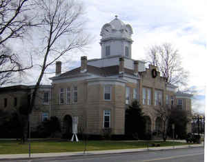
There was a fire at the Cumberland County courthouse in 1905.
Tennessee Encyclopedia of History and Culture
The land that is now Cumberland County existed as an Indian hunting ground when Tennessee became a state in 1796.
Bands of settlers making the perilous journey from Virginia, Maryland, and North and South Carolina to the
Cumberland River settlements and beyond rested at the inns located along the toll roads that crossed the region.
Kemmer's Stand, Mammy, Burke, Genesis, Lowery's Stand, and Grimes (Graham's) Stand were familiar names to early
travelers. Movement across the region became so common that Helen Krechniak, author of Cumberland County's First
Hundred Years, referred to the county as "The Road to Somewhere Else." Many of the roads were mere trails, partially
maintained between toll gates; other roads were better maintained and offered more substantial accommodations. Crab
Orchard Inn, Kemmer's Stand, and Johnson's Stand (Mayland) serviced Walton Road. That road was established by the
legislature to connect Southwest Point (Kingston) to Nashville. Today, Interstate 40 follows much of the original
route across Cumberland County.
In 1856 the Tennessee General Assembly created Cumberland County from the eight surrounding counties of Bledsoe,
Roane, Morgan, Fentress, Rhea, Putnam, Overton, and White. Covering 679 square miles of the Cumberland Plateau, the
new county rose from an elevation of eight hundred feet to a height of three thousand feet, with an average
elevation of two thousand feet. Crossville (Scott's Crossroads), near the center of the county, was chosen as the
county seat despite the fact that several other communities, including Crab Orchard, Grassy Cove, Mayland, and
Pleasant Hill, had larger populations. Find more from the Tennessee Encyclopedia of History and Culture:
CUMBERLAND COUNTY
Geography: Land and Water
As reported by the Census Bureau, the county has a total area of 685 square miles (1,774 km2), of which, 682
square miles (1,765 km2) of it is land and 3 square miles (9 km2) of it (0.49%) is water.
Neighboring Counties
Bordering counties are as follows:
- Fentress County (north)
- Overton County (northwest)
- Morgan County (northeast)
- Roane County (east)
- Rhea County (southeast)
- Bledsoe County (south)
- Van Buren County (southwest)
- White County (west)
- Putnam County (northwest)
Education
The Cumberland County School District oversees two high schools, nine elementary schools, and one charter school. Schools include Stone Memorial High School.


Click Image to Enlarge
