


Tennessee State Almanac: Facts and Figures
Quick Facts, Figures, and Overview of the State of Tennessee
Tennessee is one of the East South Central states of the US. The state of Tennessee covers a total area of 42,143 square miles (109,247 square kilometers) and its neighboring states are Kentucky, North Carolina, Virginia, Alabama, Georgia, Mississippi, Missouri, and Arkansas, making a total of eight border states, the highest number of any other state (tied with Missouri). Tennessee was named after the Little Tennessee River. Originally "Tanasi" the river took its name from two Cherokee villages on its banks.
The state is now predominantly industrial; the majority of its population lives in urban areas. Among the most important products are chemicals, textiles, apparel, electrical machinery, furniture, and leather goods. Other lines include food processing, lumber, primary metals, and metal products. The state ranks high in the production of marble, zinc, pyrite, and ball clay.
Tennessee's largest crop is soybean, contributing about 11% to the state's total agricultural receipts. The state is also a leading tobacco producer. Other farming income is derived from livestock and dairy products, as well as greenhouse and nursery products and cotton.
Tennessee Almanac: Facts on the State of Tennessee |
||
|---|---|---|
| Official Name | Tennessee | |
| Capital | Nashville | |
| Nicknames | Volunteer State ...and more | |
| Motto | Agriculture and commerce | |
| Location Region |
36.17155 N, 086.78482 W Appalachia Southern |
|
| Constitution Ratified | 1870 | |
| Statehood | June 01, 1796 16th state |
|
| Population | 6,346,105 (2010) 138.02 sq. mi. 16th |
|
| Largest City (by population) |
10 largest cities (2010est.): Memphis, 646,889; Nashville-Davidson,1 626,681; Knoxville, 178,874; Chattanooga, 167,674; Clarksville, 132,939; Murfreesboro, 108,755; Jackson, 65,211; Johnson City, 63,152; Franklin, 62,487; Bartlett, 54,613 | |
| Bordering States | North: Kentucky and Virginia East: North Carolina South: Georgia, Alabama, and Mississippi West: Arkansas and Missouri (Mississippi River forms the Western boundary) |
|
| Major Industry | mining (coal), electrical power, enriched uranium production, music, automobile manufacturing, farming (tobacco, cattle, soybeans, cotton), walking horses, tourism | |
| Major Rivers | Tennessee River, Mississippi River, Cumberland River, Clinch River, Duck River | |
| Major Lakes | Kentucky Lake, Norris Lake, Chickamauga Lake, Cherokee Lake, Tims Ford Reservoir | |
| Tennessee Counties | 95 Counties in Tennessee | |
| Largest County (by population) |
Shelby County 927,644 (2010) 755 sq. mi. |
|
| State forests | 15 (162,371 ac.) | |
| State parks | 54 | |
| Largest County (by area) |
Shelby County 755 sq. mi. |
|
| Electoral Votes | 11 | |
| US Congress | 2 Senators; 9 Representatives | |
| Time Zone | Central Standard Time | |
| Zip Codes | NANPA | |
| State Quick Facts | Census Bureau Quick Facts | |
Tennessee Climate and Weather |
||
|---|---|---|
| Tennessee tends to be hot and humid in the summer,
though the higher you go into the mountains, the cooler it gets. Temperatures range 66-90 F/19-32 C June-August, but the humidity climbs with them.
Expect thunderstorms in summer, especially in July in the Smoky Mountains. The Smokies are comfortably warm on summer days with cool nights.
Spring and autumn see cooler temperatures, 70-85 F/21-29 C, and a slight drop in humidity mean more comfortable touring. Winters are mild (seldom below 10 F/-12 C), but they're often wet. Snow rarely lasts more than a few days except in the mountains. April-May temperatures
range 53-87 F/11-30 C (42-76 F/5-24 C in the Smokies), though spring weather can be unsettled. |
||
| Highest Temperature | 113 degrees Aug 9, 1930 - Perryville |
|
| Lowest Temperature | -32 degrees December 30, 1917 - Mountain City |
|
| Avg. Temp: High - Low |
91.5 degrees - 27.8 degrees | |
Tennessee Points of Interest |
||
|
Tennessee's natural
beauty, mild weather and southern hospitality are a great combination. Not-to-be-missed attractions include Lookout Mountain; Civil War battlefields and monuments; Dollywood, Graceland and Beale Street in Memphis; the Grand Ole Opry and Opryland in Nashville; the American Museum of Atomic Energy at Oak Ridge; Great Smoky Mountains National Park; the Hermitage (Andrew Jackson's home), and much, much more. |
||
Tennessee Highest, Lowest, and Mean Elevations (Feet) |
||
| Mean Elevation: 900 feet | ||
|
Highest Point: Clingmans Dome: 6,643 feet
|
||
| Lowest Point: | Mississippi River 178 feet |
|
Tennessee Land Area (Square Miles) |
||
| Geographic Center | In Rutherford County, 5 mi. NE of Murfreesboro Longitude: 86°37.3'W Latitude: 35°47.7'N |
|
| Total Area | 42,143.27 sq. mi. 36th |
|
| Land Area | 41,217.12 sq. mi. | |
| Water Area | 926.15 sq. mi. 2.19% |
|
| Forested Land Area | 51.6% | |
| Dimensions (Length - Width) |
440 miles - 120 miles | |
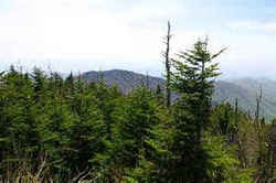 Rising 6,643 feet above the Great
Smoky Mountains, Clingman's Dome is the highest point along the Appalachian Trail and provides a 360°view of the surrounding
mountains. From it's 54 foot observation tower the average viewing distance is about 22 miles, but on a clear pollution free day, views can amplify
as far as 100 miles into 7 states.
Rising 6,643 feet above the Great
Smoky Mountains, Clingman's Dome is the highest point along the Appalachian Trail and provides a 360°view of the surrounding
mountains. From it's 54 foot observation tower the average viewing distance is about 22 miles, but on a clear pollution free day, views can amplify
as far as 100 miles into 7 states.Anderson, Bedford, Benton, Bledsoe, Blount, Bradley, Campbell, Cannon, Carroll, Carter, Cheatham, Chester, Claiborne, Clay, Cocke, Coffee, Crockett, Cumberland, Davidson, De Kalb, Decatur, Dickson, Dyer, Fayette, Fentress, Franklin, Gibson, Giles, Grainger, Greene, Grundy, Hamblen, Hamilton, Hancock, Hardeman, Hardin, Hawkins, Haywood, Henderson, Henry, Hickman, Houston, Humphreys, Jackson, Jefferson, Johnson, Knox, Lake, Lauderdale, Lawrence, Lewis, Lincoln, Loudon, Macon, Madison, Marion, Marshall, Maury, McMinn, McNairy, Meigs, Monroe, Montgomery, Moore, Morgan, Obion, Overton, Perry, Pickett, Polk, Putnam, Rhea, Roane, Robertson, Rutherford, Scott, Sequatchie, Sevier, Shelby, Smith, Stewart, Sullivan, Sumner, Tipton, Trousdale, Unicoi, Union, Van Buren, Warren, Washington, Wayne, Weakley, White, Williamson, Wilson

