


Click Image to Enlarge
Tennessee Counties
There are ninety-five counties in the State of Tennessee. The oldest county is Washington County, founded in 1777. The most recently formed county is Chester County (1879)Dyer County, Tennessee
Dyer County Education, Geography, and History
Dyer County is a county located in the westernmost part of the state of Tennessee. Based on the 2010 census, the population was 38,335. Dyer
County was founded by a Private Act of Tennessee, passed on October 16, 1823. The area was part of the territory in Tennessee that was
previously legally occupied by Chickasaw Native American people ("Indian Lands"). Its county seat is Dyersburg.
Dyer County comprises the Dyersburg, TN Micropolitan Statistical Area.
Etymology - Origin of Dyer County Name
Named in honor of Robert Henry Dyer (ca. 1774-1826), Creek and War of 1812 officer, cavalry colonel in the 1818 Seminole War, state senator, instrumental figure in formation of Dyer and Madison counties.
Demographics:
County QuickFacts: CensusBureau Quick Facts
History of Dyer County
Created 1823 from Indian lands; named in honor of Robert Henry Dyer (ca. 1774-1826), Creek and War of 1812 officer, cavalry colonel in the 1818 Seminole War, state senator, instrumental figure in formation of Dyer and Madison counties.
Dyer County was formed in 1823 from Indian lands (Private Acts of Tennessee 1823, Chapter 108).
There was a fire at the Dyer County courthouse in 1864.
Tennessee Encyclopedia of History and Culture
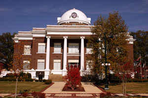
The Tennessee General Assembly established Dyer County in 1823 and named it in honor of Colonel Robert H. Dyer.
John McIver and Joel H. Dyer donated sixty acres for the new county seat, named Dyersburg, at a central location
within the county known as McIver's Bluff. In 1825 Joel Dyer surveyed the town site into eighty-six lots; the first
courthouse was built on the square in 1827. The present Classical Revival-style courthouse, designed by Asa Biggs in
1911, centers a downtown historic district listed in the National Register of Historic Places. The county's
population in 2000 was 37,279.
Fertile soil and plentiful stands of timber made Dyer County rich farming country. The early profitable crops of
corn and tobacco were replaced in the post-Civil War era by a reliance on cotton, and the timber industry expanded.
Situated at the head of steamboat navigation on the Forked Deer River, Dyersburg grew as a river town, especially
once the Grey Eagle made the first successful steamboat trip in 1836. The county was spared the worst of the Civil
War, as no major battles or other activity occurred within its borders. Dyersburg resident Otho F. Strahl raised a
local Confederate infantry company in 1861 and then steadily advanced to the rank of brigadier general in the Army
of Tennessee. On November 30, 1864, Strahl was killed at the battle of Franklin. Find more from the Tennessee Encyclopedia of History and Culture:
DYER COUNTY
Geography: Land and Water
As reported by the Census Bureau, the county has a total area of 526 square miles (1,364 km2), of which, 510
square miles (1,322 km2) of it is land and 16 square miles (41 km2) of it (3.04%) is water.
The county is bounded on the west by the Mississippi River, and it is drained by the Mississippi River. It is in the
part of Tennessee called the "Mississippi bottomland".
Dyer County is bisected by US Route 51, the older major highway connecting Memphis with Chicago from south to
north. To the west, Dyer County is connected to Missouri by Interstate 155 over the Mississippi River, providing the
only highway connection, other than those at Memphis, between Tennessee and the states to the west of "The Father of
the Waters".
Neighboring Counties
Bordering counties are as follows:
- Lake County (north)
- Obion County (northeast)
- Gibson County (east)
- Crockett County (southeast)
- Lauderdale County (south)
- Mississippi County, Arkansas (southwest)
- Pemiscot County, Missouri (northwest)
Education


Click Image to Enlarge
