


Click Image to Enlarge
Tennessee Counties
There are ninety-five counties in the State of Tennessee. The oldest county is Washington County, founded in 1777. The most recently formed county is Chester County (1879)Grainger County, Tennessee
Grainger County Education, Geography, and History
Grainger County is a county located in the state of Tennessee. Based on the 2010 census, the population was 22,657. Its county seat is
Rutledge.
Grainger County is included in the Knoxville, TN Metropolitan Statistical Area
Etymology - Origin of Grainger County Name
Named in honor of Mary Grainger (? - 1802), daughter of Kaleb Grainger of North Carolina, who married William Blount and became first lady of the Territory South of the River Ohio (later Tennessee).
Demographics:
County QuickFacts: CensusBureau Quick Facts
History of Grainger County
Created 1796 from Hawkins and Knox counties; named in honor of Mary Grainger (? - 1802), daughter of Kaleb Grainger of North Carolina, who married William Blount and became first lady of the Territory South of the River Ohio (later Tennessee).
Grainger County was formed in 1796 from Hawkins and Knox counties
(Acts of Tennessee 1796 [1st Session], Chapter 28).
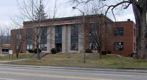
There was a fire at the Grainger County courthouse in 1946
Tennessee Encyclopedia of History and Culture
Grainger County holds the distinction as the only Tennessee county named for a woman, Mary Grainger Blount, the
wife of Territorial Governor William Blount. The state legislature formed the county in 1796 from parts of Hawkins
and Knox Counties, and it once included parts of Campbell, Claiborne, Hamblen, and Union Counties. The county seat
rotated meeting places until 1801, when a courthouse was built in Rutledge.
Nestled between the Holston and Clinch Rivers, Grainger County retains much of its rural nature. Rutledge, the
county seat, has a population approaching 2,500. Founded in 1798, the town was named in honor of General George
Rutledge of Sullivan County. Blaine, now a suburb of Knoxville, traces its origins to the 1700s, when it was known
as Blaine's Crossroads because of its proximity to the residence of Robert Blaine. George Bean Sr., goldsmith,
jeweler, and gun maker, settled Bean Station, the county's most recently chartered town (1997). Bean Station served
as a crossroads along the Old Kentucky Road (Highway 25E) and the New Orleans to Washington Road (Highway 11W).
These towns lie to the south of Clinch Mountain, which splits the county into two geographical sections. Communities
north of the mountain include Thorn Hill, Washburn, and Powder Springs. Find more from the Tennessee Encyclopedia of History and Culture:
GRAINGER COUNTY
Geography: Land and Water
Grainger County is bounded on the northwest by the Clinch River (impounded by Norris Dam to form Norris Lake) and
on the southeast by the Holston River (including Cherokee Lake). As reported by the Census Bureau, the county has
a total area of 302 square miles (783 km2), of which, 280 square miles (726 km2) of it is land and 22 square miles
(57 km2) of it (7.31%) is water. Clinch Mountain is a major geographic feature that effectively separates the county
into a southern section (including Rutledge) and a northern section (including Washburn).
Neighboring Counties
Bordering counties are as follows:
- Hancock County and Hawkins County (northeast)
- Hamblen County (east)
- Jefferson County (south)
- Knox County (southwest)
- Union County (west)
- Claiborne County (northwest)
Education


Click Image to Enlarge
