


Click Image to Enlarge
Tennessee Counties
There are ninety-five counties in the State of Tennessee. The oldest county is Washington County, founded in 1777. The most recently formed county is Chester County (1879)Robertson County, Tennessee
Robertson County Education, Geography, and History
Robertson County is a county located in the state of Tennessee. Based on the 2010 census, the population was 66,283. Its county seat is
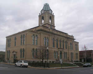
Springfield. The county was named for James Robertson, founder of Nashville and a state senator.
Robertson County is a component of the Nashville-Davidson–Murfreesboro–Franklin, TN Metropolitan Statistical Area.
Etymology - Origin of Robertson County Name
Named in honor of James Robertson (1742- 1814), pioneer, surveyor, soldier, founder of the Watauga Settlements and of Nashville, and state senator, known as "Father of Tennessee."
Demographics:
County QuickFacts: CensusBureau Quick Facts
History of Robertson County
Created 1796 from Tennessee and Sumner counties; named in honor of James Robertson (1742- 1814), pioneer, surveyor, soldier, founder of the Watauga Settlements and of Nashville, and state senator, known as "Father of Tennessee."
Robertson County was formed in 1796 from Tennessee and Sumner counties. (Acts of 1788 [North Carolina], Chapter 28).
Tennessee Encyclopedia of History and Culture
The first white settlement in Robertson County was established by Thomas Kilgore, who came there in 1778 claiming
land and building a station in 1779 near present-day Cross Plains. Prior to statehood this area was one of the
counties in Mero District and called Tennessee County, located north of Nashville on the Kentucky border.
One of the first acts of the new state was to appropriate Tennessee County's name for its own use and to divide that
county into Robertson and Montgomery Counties. Robertson County took its name from General James Robertson, often
called the "Father of Middle Tennessee." Robertson County, established by the general assembly on April 9, 1796,
covered 477 square miles and contained 304,640 acres.
The enabling act, which created the new county appointed commissioners and instructed them to establish the county
government system and "to lay off, and appoint a place, the most centrical and convenient in the county of
Robertson, for the purpose of erecting a courthouse prison and stocks." By 1798 Thomas Johnson had surveyed and laid
out the county seat of Springfield, and the lots sold for eight dollars each. Find more from the Tennessee Encyclopedia of History and Culture:
ROBERTSON COUNTY
Geography: Land and Water
As reported by the Census Bureau, the county has a total area of 477 square miles (1,235 km2), of which, 476
square miles (1,234 km2) of it is land and 0 square miles (1 km2) of it (0.04%) is water.
Neighboring Counties
Bordering counties are as follows:
- Logan County, Kentucky (north)
- Simpson County, Kentucky (northeast)
- Sumner County (east)
- Davidson County (south)
- Cheatham County (southwest)
- Montgomery County (west)
- Todd County, Kentucky (northwest)
Education


Click Image to Enlarge
