


Click Image to Enlarge
Tennessee Counties
There are ninety-five counties in the State of Tennessee. The oldest county is Washington County, founded in 1777. The most recently formed county is Chester County (1879)Sullivan County, Tennessee
Sullivan County Education, Geography, and History
Sullivan County is a county located in the state of Tennessee. Based on the 2010 census, the population was 156,823. Sullivan is Tennessee's
second-oldest county, having been established in 1779 when the area was still part of North Carolina. It was part of the extra-legal State of
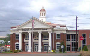
Franklin from 1784 to 1788. Its county seat is Blountville.
Sullivan County is part of the Kingsport-Bristol-Bristol, TN-VA Metropolitan Statistical Area, which is a component of the Johnson
City-Kingsport-Bristol, TN-VA Combined Statistical Area, commonly known as the "Tri-Cities" region.
Etymology - Origin of Sullivan County Name
Named in honor of John Sullivan (1740-1795), Revolutionary War officer, member of the Continental Congress, attorney general, legislator, US district judge and governor of New Hampshire.
Demographics:
County QuickFacts: CensusBureau Quick Facts
History of Sullivan County
Created 1779 from Washington County; named in honor of John Sullivan (1740-1795), Revolutionary War officer, member of the Continental Congress, attorney general, legislator, US district judge and governor of New Hampshire.
Sullivan County was formed in 1779 from Washington County (Acts of 1779 [North Carolina], Chapter 29).
There was a fire at the Sullivan County courthouse in 1863.
Tennessee Encyclopedia of History and Culture
Established in 1780, Sullivan County was one of the earliest settled areas in Tennessee. In 1761 troops on their
way to aid besieged Fort Loudoun passed through this area of northeast Tennessee, built the Island Road, and
constructed Fort Robinson on the Long Island of the Holston. Settlement of the area began shortly after the fort was
constructed. The first permanent settlers came from Lancaster, Pennsylvania, in 1765. This area was known as the
North of the Holston Settlement and was considered part of Virginia until a boundary survey proved it to be part of
North Carolina in 1779. The county of Sullivan, named for General John Sullivan, a New Hampshire Revolutionary War
leader, was officially organized in February 1780.
The Holston River crosses the county from northeast to southwest. At the southwest corner, the Holston and Watauga
Rivers come together in the Forks area. The north fork of the Holston forms the county boundary with Hawkins County,
which was created out of Sullivan in 1786. The Long Island's strategic location at the head of navigation on the
Holston figured prominently in campaigns against the Cherokees and during the American Revolution, when Fort Patrick
Henry stood on the old site of Fort Robinson. It was a docking place for boats laden with commodities like iron and
salt bound for towns downriver. White settlers defeated the Cherokee in their attempts to resist settlement in the
famous battle of Island Flats in 1776. The Treaty of the Long Island of the Holston in 1777 temporarily resolved
conflicts between settlers and the Cherokee, who ceded lands to both Virginia and North Carolina. At a location
nearby, Colonel John Donelson assembled his family and other settlers for a voyage down the Holston to establish a
settlement on the Cumberland River in December 1779. The river routes through the county, as well as the early roads
cut in the area, made it a gateway for western settlement as immigrants moved down the Valley of Virginia from
Delaware, Maryland, Pennsylvania, Virginia, and across the Carolinas. Find more from the Tennessee Encyclopedia of History and Culture:
SULLIVAN COUNTY
Geography: Land and Water
As reported by the Census Bureau, the county has a total area of 430 square miles (1,113 km2), of which, 413
square miles (1,070 km2) of it is land and 17 square miles (43 km2) of it (3.88%) is water. Sullivan County's
boundary with Carter County and Johnson County is defined as the ridgeline of Holston Mountain.
Neighboring Counties
Bordering counties are as follows:
- Washington County, Virginia & Bristol, Virginia (northeast)
- Johnson County (east)
- Carter County (southeast)
- Washington County (southwest)
- Hawkins County (west)
- Scott County, Virginia (northwest)
Education


Click Image to Enlarge
