


Click Image to Enlarge
Tennessee Counties
There are ninety-five counties in the State of Tennessee. The oldest county is Washington County, founded in 1777. The most recently formed county is Chester County (1879)Wilson County, Tennessee
Wilson County Education, Geography, and History
Wilson County is a county located in the state of Tennessee. Based on the 2010 census, the population was 113,993. Its county seat is
Lebanon. The largest city in the county is Mt. Juliet.
Wilson County is part of the Nashville-Davidson–Murfreesboro–Franklin, TN Metropolitan Statistical Area.
Etymology - Origin of Wilson County Name
Named in honor of David Wilson (1752-1804?), Revolutionary War soldier, member of the North Carolina legislature and the legislature of the Territory South of the River Ohio (later Tennessee).
Demographics:
County QuickFacts: CensusBureau Quick Facts
History of Wilson County
Created 1799 from Sumner County; named in honor of David Wilson (1752-1804?), Revolutionary War soldier, member of the North Carolina legislature and the legislature of the Territory South of the River Ohio (later Tennessee).
Wilson County was formed in 1799 from Sumner County. (Acts of Tennessee 1799, Chapter 2).
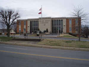
There was a fire at the Wilson County courthouse in 1881.
Tennessee Encyclopedia of History and Culture
The Tennessee General Assembly created Wilson County on October 26, 1799. Its prehistoric heritage is rich. The
Sellars temple mound on Spring Creek, for example, yielded an outstanding piece of pre-Columbian sculpture that has
been the emblem of the Tennessee Archaeological Society. Europeans explored the land long before settlement: French
trappers arrived as early as 1760, and the hunting party of Henry Scraggins passed through the area in 1765. John B.
Walker led the first permanent settlers to Hickory Ridge, west of the present site of Lebanon, in 1794.
The county was named for Major David Wilson, a North Carolina hero of the American Revolution. Lebanon was named for
the impressive stands of red cedar trees (actually Virginia juniper) that are characteristic of the region. In the
late 1930s Tennessee and the federal government created the Cedars of Lebanon State Park in recognition of this
botanical feature. Lebanon was chosen as the county seat in 1801, largely because of a large spring (still flowing)
on what became the public square. The county has had five courthouses; the building of 1848-81 was designed by the
noted architect William Strickland. Other towns and villages include Watertown, Green Hill, Mt. Juliet, Statesville,
Gladesville, Baird's Mill, Norene, Cherry Valley, Shop Springs, Tucker's Cross Roads, Leeville, Martha, Bellwood,
Commerce, Taylorsville, Centreville, Oakland, LaGuardo, and Maple Hill. Find more from the Tennessee Encyclopedia of History and Culture:
WILSON COUNTY
Geography: Land and Water
As reported by the Census Bureau, the county has a total area of 583 square miles (1,510 km2), of which, 571
square miles (1,478 km2) of it is land and 13 square miles (33 km2) of it (2.17%) is water.
Neighboring Counties
Bordering counties are as follows:
- Trousdale County (north)
- Smith County (northeast)
- DeKalb County (east)
- Cannon County (southeast)
- Rutherford County (south)
- Davidson County (west)
- Sumner County (northwest)
Education
Wilson County Schools oversees 22 public schools, including 2 adult education centers and a technical education center. The county has four
high schools: Lebanon High School, Wilson Central High School, Watertown High School and Mount Juliet High School.
Cumberland University is located in Lebanon.


Click Image to Enlarge
