


Click Image to Enlarge
Texas Counties
Texas is divided into two hundred and fifty-four counties, more than any other state. Texas was originally divided into municipalities, a unit of local government under Spanish and Mexican rule. When the Republic of Texas gained its independence in 1836, there were 23 municipalities, which became the original Texas counties. Many of these would later be divided into new counties. The most recent county to be created was Kenedy County in 1921. The most recent county to be organized was Loving County in 1931Bell County, Texas
Bell County Education, Geography, and History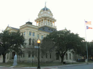
Bell County is a county located in the state of Texas. Based on the 2010 census, its population was 310,235. Its county seat is
Belton. The county was founded in 1850 and is named for Peter Hansborough Bell, the third governor of Texas.
Bell County is part of the Killeen-Temple, TX Metropolitan Statistical Area.
Etymology - Origin of Bell County Name
Peter Hansborough Bell, the third governor of Texas
Demographics:
County QuickFacts: CensusBureau Quick Facts
BellCounty History
Bell County was created from Milam County just five years after Texas entered the Union. Bell is named for Peter Hansborough Bell, the third governor of Texas.
County Commissioners chose a county seat on the banks of Nolan Creek and named it Nolandsville. Two years later, January 12, 1852, the
town's name became Belton and it was incorporated. Belton's first settlers built houses, stores, saloons, and a hotel and prospered until
the Civil War when they lined up behind the South. When things went bad for the South, Belton also experienced tough times. By the
1880s, Belton had recovered from the war and began to flourish once again. It was the largest town in Bell County and had a brisk
economy. Belton would have become a boom town if it had a railroad, but it only reached its doorstep as the Santa Fe Railroad crossed the
county line on the eastern edge near Rogers. During the mid to late 1860s, the Chisholm Trail cut through central Bell County along a
route between the present day cities of Belton and Salado. The 1860's also saw the establishment of the female religious commune known as
the True Church Colony which flourished until about 1900.
Handbook of Texas Online
Settlers began to return to the Bell County area after the peace treaties of 1843-44, and Indian
raids into the county became less frequent. By the census of 1850, the population of what would
shortly become Bell County was approximately 600 whites and sixty black slaves. Bell County was
formed on January 22, 1850, and named for Peter H. Bell. The
election held to organize the county took place in April at the "Charter Oak," near the center of
the county at the military crossing on the Leon River. Nolan Springs was chosen as the county seat
and named Nolanville. On December 16, 1851, the name was changed to Belton. In 1854 Coryell County
was marked off from Bell County, and in 1856 the legislature attached a six-mile-wide strip of Falls
County to Bell County. In 1860, when a resurvey of the line between Bell and Milam counties was made
and recognized by the legislature, Bell County assumed its present boundaries. More at
Seymour V. Connor and Mark Odintz, "BELL COUNTY," Handbook of Texas Online (http://www.tshaonline.org/handbook/online/articles/hcb06),
accessed January 23, 2016. Uploaded on June 12, 2010. Modified on January 22, 2016. Published by the Texas State Historical
Association.
Geography: Land and Water
As reported by the Census Bureau, the county has a total area of 1,088 square miles (2,818
km2), of which, 1,060 square miles (2,745 km2) of it is land and 28 square miles (73 km2) of it
(2.59%) is water.
Neighboring Counties
Bordering counties are as follows:
- McLennan County (north)
- Falls County (northeast)
- Milam County (southeast)
- Williamson County (south)
- Burnet County (southwest)
- Lampasas County (west)
- Coryell County (northwest)
Education
Bell County is served by several school districts:
Academy Independent School District
Bartlett Independent School District (partial)
Belton Independent School District
Bruceville-Eddy Independent School District (partial)
Copperas Cove Independent School District (partial)
Florence Independent School District (partial)
Gatesville Independent School District (partial)
Holland Independent School District (partial)
Killeen Independent School District (partial)
Lampasas Independent School District (partial)
Moody Independent School District (partial)
Rogers Independent School District (partial)
Rosebud-Lott Independent School District (partial)
Temple Independent School District
Troy Independent School District
Salado Independent School District


Click Image to Enlarge
