


Click Image to Enlarge
Texas Counties
Texas is divided into two hundred and fifty-four counties, more than any other state. Texas was originally divided into municipalities, a unit of local government under Spanish and Mexican rule. When the Republic of Texas gained its independence in 1836, there were 23 municipalities, which became the original Texas counties. Many of these would later be divided into new counties. The most recent county to be created was Kenedy County in 1921. The most recent county to be organized was Loving County in 1931Blanco County, Texas
Blanco County Education, Geography, and History
Blanco County is a county located on the Edwards Plateau in the state of Texas. Based on the 2010 census, the population was 10,497. Its county seat is Johnson City. The county is named for the Blanco River which traverses the county. The State of Texas formed Blanco County in 1858 from portions of Burnet, Comal, Gillespie and Hays counties. The city of Blanco served as the county seat from 1858 to 1890, when it was moved to Johnson City.
Etymology - Origin of Blanco County Name
the Blanco River (Blanco means white in Spanish)
Demographics:
County QuickFacts: CensusBureau Quick Facts
Blanco County History
Blanco County was formed February 12, 1858 from parts of Comal, Hays, Burnet, and Gillespie Counties and named for the Blanco River. It comprises 714 square miles of the eastern edge of the Edwards Plateau. Johnson City, the county seat, is four miles north of the center of the county. The city of Blanco served as the county seat from 1858 to 1890, when it was moved to Johnson City.
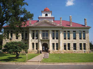
A courthouse was constructed on the town square in 1860. It was replaced in 1885 by a limestone structure that came to be known as the Old
Courthouse after Johnson City became the county seat. The Old Courthouse was restored in the early 1990s.
Handbook of Texas Online
In 1855 settlers in the western part of what was then Comal County began to
agitate for a new county. As a result, Kerr County was established in 1856.
This, however, did not help the people of northern Comal County. They
continued to petition the legislature, and through the efforts of members of
the Pittsburgh Land Company, Blanco County was formed on February 12, 1858,
from parts of Comal, Hays, Burnet, and Gillespie counties and named for the
Blanco River. Some historians believe that Blanco County also acquired two
small unattached pieces of Travis County. The total area of the new county
was 1,043 square miles. More at
Mary H. Ogilvie and John Leffler, "BLANCO COUNTY," Handbook of Texas Online (http://www.tshaonline.org/handbook/online/articles/hcb08),
accessed January 23, 2016. Uploaded on June 12, 2010. Modified on January 22, 2016. Published by the Texas State Historical Association.
Geography: Land and Water
Blanco County is located in the Hill Country of central Texas, west of
Austin and north of San Antonio. Two significant rivers, the Blanco River
and the Pedernales River, flow through the county.
As reported by the Census Bureau, the county has a total area of 713
square miles (1,848 km2), of which, 711 square miles (1,842 km2) of it is
land and 2 square miles (6 km2) of it (0.30%) is water.
Neighboring Counties
Bordering counties are as follows:
- Burnet County (north)
- Travis County (northeast)
- Hays County (east)
- Comal County (southeast)
- Kendall County (southwest)
- Gillespie County (west)
- Llano County (northwest)
Education


Click Image to Enlarge
