


Click Image to Enlarge
Texas Counties
Texas is divided into two hundred and fifty-four counties, more than any other state. Texas was originally divided into municipalities, a unit of local government under Spanish and Mexican rule. When the Republic of Texas gained its independence in 1836, there were 23 municipalities, which became the original Texas counties. Many of these would later be divided into new counties. The most recent county to be created was Kenedy County in 1921. The most recent county to be organized was Loving County in 1931Cooke County, Texas
Cooke County Education, Geography, and History
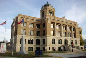
Cooke County is a county located in the state of Texas. Based on the 2010 census, its population was 38,437. The county seat is Gainesville.
The county was founded in 1848 and organized the next year. It is named for William Gordon Cooke, a soldier during the Texas Revolution. It is
a part of the Texoma region.
Cooke County comprises the Gainesville, TX Micropolitan Statistical Area, which is also included in the Dallas-Fort Worth, TX-OK Combined
Statistical Area.
Etymology - Origin of Cooke County Name
William Gordon Cooke, a soldier during the Texas Revolution
Demographics:
County QuickFacts: CensusBureau Quick Facts
Cooke County History
Cooke County is a county located in the US state of Texas. It is named for William Gordon Cooke, a soldier during the Texas Revolution. The county seat is Gainesville
Handbook of Texas Online
Cooke County was established by an act of the Texas legislature on March 20, 1848, and named for William G.
Cooke, a hero of the Texas Revolution. The
boundaries of the original county encompassed its present area, along with territory that became Montague, Clay,
Wise, and Jack counties. Cooke County assumed its present boundaries in 1857. It was crossed by several early
trails, including the Mormon Trail, a branch of the Chisholm Trail, and the
Butterfield Overland Mail route. Settlements in the northern extension of the
Peters colony reached the southeastern edge of the county by the late 1840s.
Fort Fitzhugh was established in 1847 to protect area settlements against Indian raids, the last of which occurred
in the western part of the county in January 1868. Early settlers employed Daniel Montague
to locate a site for a county seat fifteen miles west of the Grayson county line. They planned to name the town
Liberty, but the state rejected that name because another settlement near Houston had claimed it. Col. William F.
Fitzhugh, commander at the fort, proposed that the town be named for his former
commander, Gen. Edmund Pendleton Gaines. Gainesville, founded in 1850, has been
the county seat since the organization of the county. The southern and eastern parts of the county were settled by
people primarily from Tennessee, Arkansas, and Missouri. The western part had only scattered settlements prior to
the late nineteenth century, when German land speculators founded the towns of Muenster in 1889 and Lindsay in 1891. More at
Robert Wayne McDaniel, "COOKE COUNTY," Handbook of Texas Online (http://www.tshaonline.org/handbook/online/articles/hcc22),
accessed January 23, 2016. Uploaded on June 12, 2010. Published by the Texas State Historical Association.
Geography: Land and Water
As reported by the Census Bureau, the county has a total area of 899 square miles (2,328 km2), of which, 874
square miles (2,263 km2) of it is land and 25 square miles (65 km2) of it (2.80%) is water.
Neighboring Counties
Bordering counties are as follows:
- Love County, Oklahoma (north)
- Grayson County (east)
- Denton County (south)
- Wise County (southwest)
- Montague County (west)
Education


Click Image to Enlarge
