


Click Image to Enlarge
Texas Counties
Texas is divided into two hundred and fifty-four counties, more than any other state. Texas was originally divided into municipalities, a unit of local government under Spanish and Mexican rule. When the Republic of Texas gained its independence in 1836, there were 23 municipalities, which became the original Texas counties. Many of these would later be divided into new counties. The most recent county to be created was Kenedy County in 1921. The most recent county to be organized was Loving County in 1931DeWitt County, Texas
DeWitt County Education, Geography, and History
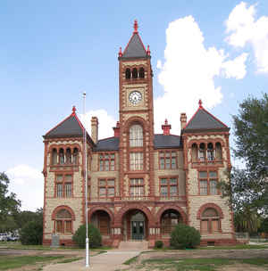
DeWitt County is a county located in the state of Texas. Based on the 2010 census, its population was 20,097. The county seat is Cuero. The county was founded in 1846 and is named for Green DeWitt, who founded an early colony in Texas.
Etymology - Origin of DeWitt County Name
Green DeWitt, who founded an early colony in Texas
Demographics:
County QuickFacts: CensusBureau Quick Facts
DeWitt County History
Archeological digsindicate early habitation from the Paleo-Indians Hunter-gatherers period. Later, Tonkawa, Aranamas,
Tamiques, Karankawa. Tawakoni, Lipan Apache and Comanche lived and hunted in the county.
The first European visitors to the county are thought to have been Alvar Nunez Cabeza de Vaca, Alonso del Castillo Maldonado, Andrés Dorantes de
Carranza, and his slave Estevanico of the ill-fated 1528 Narváez expedition. French explorer René Robert Cavelier, Sieur de La Salle is believed to
have crossed the county on his way westward from Victoria County; and while La Bahia was a common route, no evidence of any settlements exist before
the Anglo homesteaders.
In 1825, empresario Green DeWitt received a grant from the Coahuila y Tejas legislature to settle 400 families. Between 1826 and 1831[ settlers
arrived from Tennessee, Kentucky, Missouri, and other Southern states.
A temporary county government was set up in 1846, with the county seat being Daniel Boone Friar's store at the junction of the La Bahía Road and the
Gonzales-Victoria road. On November 28, 1850, Clinton became the county seat until Cuero became county seat in 1876.
DeWitt County is named for Green DeWitt, who founded an early colony in Texas. The seat of the county is Cuero
Handbook of Texas Online
DEWITT COUNTY. DeWitt County is on the Gulf Coast Plain in southeastern Texas about forty-five miles
inland from Copano Bay. It is bounded by Victoria, Goliad, Karnes, Gonzales, and Lavaca counties. Cuero, the
county's largest town, serves as the county seat. The center point is at 29005' north latitude and 97023' west
longitude. Although the present county was part of DeWitt's colony and
settlement dates to colonization in 1825, the county officially has two dates of origin. The first, DeWitt County (Judicial),
was formed on February 2, 1842, but was declared unconstitutional along with other judicial counties later that
autumn. The present DeWitt County was formed from Goliad, Gonzales, and Victoria counties in 1846 and named for
empresario Green DeWitt. It comprises 910
square miles, most of which is nearly level to sloping; the areas of greatest elevation are mostly in the northwest.
The elevation ranges from about 150 feet above sea level in the east corner to more than 540 feet above sea level in
the southwest. The eastern corner and an area along the Gonzales county line falls in the Post Oak Savannah belt,
characterized by tall grasses and, along streams, oak, elm, and pecan trees. Most of the county is part of the South
Texas Plains, surfaced primarily by dark calcareous clays and sandy and clay loams that support tall grasses, small
trees, shrubs, and crops. The climate is humid-subtropical. The temperature ranges from an average high of 960 F in
July to an average low of 440 in January; records of 20 and 1100 were recorded in 1949 and 1954 respectively. The
average length of the frost-free season is 270 days, from early March to late November. The annual precipitation
averages 33.37 inches, commonly in the form of thundershowers. Most of the county is drained by the Guadalupe River
and its tributaries, which include the various branches of Coleto Creek, and also Sandies, Salt, Smith, McCoy,
Irish, Cuero, and Clear creeks. Small areas in the northern part of the county are drained by the Lavaca River, and
a small area in the southern part by the San Antonio River. Typical mammals in the county include white-tail deer,
bobcats, coyotes, opossums, squirrels, foxes, armadillos, skunks, bats, cottontail rabbits, raccoons, badgers, and
the Plains pocket gopher, as well as numerous reptile, fish, and bird species. More at
Craig H. Roell, "DEWITT COUNTY," Handbook of Texas Online (http://www.tshaonline.org/handbook/online/articles/hcd07),
accessed January 23, 2016. Uploaded on June 12, 2010. Published by the Texas State Historical Association.
Geography: Land and Water
As reported by the Census Bureau, the county has a total area of 910 square miles (2,358 km2), of which, 909
square miles (2,355 km2) of it is land and 1 square miles (3 km2) of it (0.14%) is water.
Neighboring Counties
Bordering counties are as follows:
- Lavaca County (northeast)
- Victoria County (southeast)
- Goliad County (south)
- Karnes County (southwest)
- Gonzales County (northwest)
Education


Click Image to Enlarge
