


Click Image to Enlarge
Texas Counties
Texas is divided into two hundred and fifty-four counties, more than any other state. Texas was originally divided into municipalities, a unit of local government under Spanish and Mexican rule. When the Republic of Texas gained its independence in 1836, there were 23 municipalities, which became the original Texas counties. Many of these would later be divided into new counties. The most recent county to be created was Kenedy County in 1921. The most recent county to be organized was Loving County in 1931Fort Bend County, Texas
Fort Bend County Education, Geography, and History
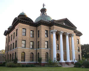
Fort Bend County is a county in the state of Texas. Based on the 2010 census, its population was 585,375, making it the tenth-most populous
county in Texas. The county seat is Richmond, while its largest city is Sugar Land. The county was founded in 1837 and organized the next
year. It is named for a blockhouse at a bend of the Brazos River; the fort was the start of the community in early days.
Fort Bend County is included in the Houston-The Woodlands-Sugar Land Metropolitan Statistical Area.
Etymology - Origin of Fort Bend County Name
a blockhouse positioned in a bend of the Brazos River which was the center of life in the future county in early days
Demographics:
County QuickFacts: CensusBureau Quick Facts
Fort Bend County History
Fort Bend County is a county located along the Gulf Coast region in the US state of Texas. Since the 1970s Fort Bend County has been one of the fastest growing counties in the United States. It is named for a blockhouse positioned in a bend of the Brazos River, which was the center of life in the future county in early days. Its county seat is Richmond, while its largest city is Sugar Land.
Handbook of Texas Online
In May 1837 the Congress of the Republic of Texas passed an act incorporating
nineteen towns, including Richmond. Robert Eden Handy of Pennsylvania and
William Lusk of Richmond, Virginia, both of whom had arrived in Texas shortly before the war for independence from
Mexico, founded and named the town with eight other proprietors, including Branch T. Archer, Thomas Freeman
McKinney, and Samuel May Williams. An act establishing Fort Bend County and
fixing its boundaries was passed on December 29, 1837; Wyly Martin was appointed
the first chief justice. On January 13, 1838, the citizens voted to make Richmond the county seat. The county was
taken from portions of Austin, Brazoria, and Harris counties. Its irregular shape was, in part, the result of using
waterways to form the west and segments of the south and east boundaries. Several efforts have been made to change
the lines but with little success. More at
Virginia Laird Ott, "FORT BEND COUNTY," Handbook of Texas Online (http://www.tshaonline.org/handbook/online/articles/hcf07),
accessed January 23, 2016. Uploaded on June 12, 2010. Published by the Texas State Historical Association
Geography: Land and Water
As reported by the Census Bureau, the county has a total area of 886 square miles (2,295 km2), of which, 875
square miles (2,265 km2) of it is land and 11 square miles (30 km2) of it (1.29%) is water.
Neighboring Counties
Bordering counties are as follows:
- Waller County (north)
- Harris County (east)
- Brazoria County (southeast)
- Wharton County (southwest)
- Austin County (northwest)
Education
Community colleges
Houston Community College System
Wharton County Junior College
University centers
University of Houston System at Cinco Ranch
University of Houston System at Sugar Land


Click Image to Enlarge
