


Click Image to Enlarge
Texas Counties
Texas is divided into two hundred and fifty-four counties, more than any other state. Texas was originally divided into municipalities, a unit of local government under Spanish and Mexican rule. When the Republic of Texas gained its independence in 1836, there were 23 municipalities, which became the original Texas counties. Many of these would later be divided into new counties. The most recent county to be created was Kenedy County in 1921. The most recent county to be organized was Loving County in 1931Goliad County, Texas
Goliad County Education, Geography, and History
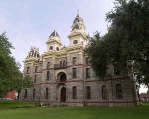
Goliad County is a county located in the state of Texas. Based on the 2010 census, the population is 7,210. Its county seat is Goliad.
The county is named for Father Miguel Hidalgo; "Goliad" is an anagram of Hidalgo, minus the silent H. The county was created in 1836 and
organized the next year.
Goliad County is a part of the Victoria, TX Metropolitan Statistical Area.
Etymology - Origin of Goliad County Name
its county seat, which preceded the modern county. Goliad is named for the Mexican Municipality of Goliad, which in turn is named for Father Miguel Hidalgo; "Goliad" is an anagram of Hidalgo, minus the silent H.
Demographics:
County QuickFacts: CensusBureau Quick Facts
Goliad County History
Goliad County is a county located in the US state of Texas. Its county seat is Goliad. Goliad is named for the Mexican Municipality of Goliad, which in turn is named for Father Miguel Hidalgo; "Goliad" is an anagram of Hidalgo, minus the silent H.
Handbook of Texas Online
Goliad County became one of the twenty-three original counties established by the First Congress of the Republic
of Texas in 1836. Resettlement was slow, primarily centered around the La Bah?-Goliad town, which remained the
business center, but also at nearby areas that became the towns of Charco and Fannin. Also, Schroeder and Weesatche
were settled by the German immigrations of the 1840s, which made Goliad County, like neighboring DeWitt and Victoria
counties, a large area of German location. Despite some crop cultivation, the county's chief industry remained ranching,
dominated by Americans. Mexican residents engaged mainly in carting merchandise from the coast to the interior,
especially along the Indianola-Goliad-San Antonio Road. This business, however, became so important that in 1857
a "war" was fought among Mexican-Texan and Anglo-Texan teamsters for its control (see CART WAR). The instigators
of this war were among those hanged from the boughs of Goliad's "Hanging Tree," believed to be one of the oldest
oaks in Texas and recurrently used as the venue for executions. Goliad during the republic was described by one
resident as "a `wild, recky, Indiany looking place'...full of lawless men [who] would throw the rawhide on to [anyone]
in a way that was a pity and a caution." Indian raids were frequently perpetrated, especially by Lipan Apaches,
Comanches, and Karankawas. The convergence of roads that underpinned Goliad's historically strategic location also
made the county vulnerable during the Mexican invasions of 1842, when Rafael
Vaquez entered the county. The Texans who formed the retaliatory Mier expedition
also passed through the county. During the republic Goliad also had one of the many horse-racing courses popular
in the new nation, a tradition still kept alive by La Bahia Downes. This racetrack near Goliad, organized in 1961,
is the oldest one in Texas as measured in consecutive years of quarter horse
races. The boundaries of Goliad County as fixed on December 2, 1841, by the Sixth Congress of the republic were
changed a number of times. Though the county had been enlarged in 1841, when the Refugio county line was adjusted,
it was reduced under the republic by the establishment of DeWitt County in 1842 and further reduced under the state
legislature by the organization of DeWitt County in 1846, the establishment of Karnes County in 1854, and the formation
of Bee County in 1857. Goliad County was further diminished when the Victoria-Goliad county line was moved from
Coleto Creek to the San Antonio River in 1861. More at
Craig H. Roell, "GOLIAD COUNTY," Handbook of Texas Online (http://www.tshaonline.org/handbook/online/articles/hcg06),
accessed January 23, 2016. Uploaded on June 15, 2010. Published by the Texas State Historical Association.
Geography: Land and Water
As reported by the Census Bureau, the county has a total area of 859 square miles (2,226 km2), of which, 854
square miles (2,211 km2) of it is land and 6 square miles (15 km2) of it (0.68%) is water.
Neighboring Counties
Bordering counties are as follows:
- DeWitt County (north)
- Victoria County (northeast)
- Refugio County (southeast)
- Bee County (southwest)
- Karnes County (northwest)
Education


Click Image to Enlarge
