


Click Image to Enlarge
Texas Counties
Texas is divided into two hundred and fifty-four counties, more than any other state. Texas was originally divided into municipalities, a unit of local government under Spanish and Mexican rule. When the Republic of Texas gained its independence in 1836, there were 23 municipalities, which became the original Texas counties. Many of these would later be divided into new counties. The most recent county to be created was Kenedy County in 1921. The most recent county to be organized was Loving County in 1931Hale County, Texas
Hale County Education, Geography, and History
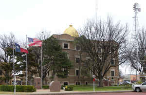
Hale County is a county located in the state of Texas. Based on the 2010 census, its population was 36,273. The county seat is Plainview.
The county was created in 1876 and organized in 1888. It is named for Lt. John C. Hale, a hero of the Battle of San Jacinto. It is home of the
noted former Hale County Judge, Judge Bill Hollars a.k.a. "Hang 'Em High" Hollars.
Hale County comprises the Plainview, TX Micropolitan Statistical Area.
Etymology - Origin of Hale County Name
John C. Hale, a lieutenant killed in action at the Battle of San Jacinto during the Texas Revolution
Demographics:
County QuickFacts: CensusBureau Quick Facts
Hale County History
Hale County is a county located in the US state of Texas. It was organized in 1888, and is named for Lt. John C. Hale, a hero of the Battle of San Jacinto. The seat of the county is Plainview
Handbook of Texas Online
Important evidence of early man was discovered in 1941 within the city limits of Plainview, where a fossil bed
yielded the skeletons of a hundred bison and more than two dozen flint tools, including a distinctive projectile
point used with a spear or atlatl; this type of point has been called the Plainview point since its discovery.
Radiocarbon dating of articles found in the excavation demonstrated that human beings lived in the area about 9,000
years ago. Comanches hunted in the area from the early eighteenth century to the 1870s, preying on the large herds
of buffalo that roamed the plains. By 1876, when Hale County was marked off from
Bexar County, both the Comanches and the buffalo had disappeared. The wealth of the isolated country was not
immediately obvious, although there was some money to be made from the bone business
and from taming mustangs. The first cattle were brought into the area in 1881,
when Illinois brothers named Morrison established the Cross L Ranch, which covered twenty square miles at the
corners of Hale, Lamb, Castro, and Swisher counties (the Morrisons later sold the spread to C. C. Slaughterqv). The
first permanent settler in the county was Horatio Graves, a Methodist minister and farmer, who purchased four
sections and moved into the area in 1883; he experimented with farming by growing garden and feed crops. Within the
next two years other settlers, including A. E. Adams, A. N. Jones, D. L. Shepley, and F. M. and L. T. Lester, moved
into the county with their families. Once a month Graves carried the mail for local ranchers and other settlers from
Estacado to a post office he established in 1884. His home became the center of the community during the early years
of settlement; church services and school classes were held there. In 1886 another early settler, Z. T. Maxwell,
located his homestead at the site of two hackberry groves on the old military trail established by Col. Ranald S.
Mackenzie. The town of Plainview later grew around Maxwell's settlement. After
establishing Hale County in 1876 the Texas legislature attached it successively to Baylor, Donley, and Crosby
counties for administrative purposes. The county was organized in 1888, with Plainview as county seat. In 1890 the
census counted 721 residents. More at
John Leffler, "HALE COUNTY," Handbook of Texas Online (http://www.tshaonline.org/handbook/online/articles/hch01),
accessed January 23, 2016. Uploaded on June 15, 2010. Published by the Texas State Historical Association.
Geography: Land and Water
As reported by the Census Bureau, the county has a total area of 1,005 square miles (2,602 km2), virtually all
of which is land.
Neighboring Counties
Bordering counties are as follows:
- Swisher County (north)
- Floyd County (east)
- Lubbock County (south)
- Lamb County (west)
- Castro County (northwest)
Education


Click Image to Enlarge
