


Click Image to Enlarge
Texas Counties
Texas is divided into two hundred and fifty-four counties, more than any other state. Texas was originally divided into municipalities, a unit of local government under Spanish and Mexican rule. When the Republic of Texas gained its independence in 1836, there were 23 municipalities, which became the original Texas counties. Many of these would later be divided into new counties. The most recent county to be created was Kenedy County in 1921. The most recent county to be organized was Loving County in 1931Hamilton County, Texas
Hamilton County Education, Geography, and History
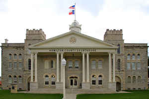
Hamilton County is a county located on the Edwards Plateau in the state of Texas. Based on the 2010 census, its population was 8,517.] The county seat is Hamilton. The county was created in 1858. It is named for James Hamilton Jr., a former governor of South Carolina who gave financial aid to the Republic of Texas.
Etymology - Origin of Hamilton County Name
James Hamilton Jr., the twenty-eighth governor of South Carolina who gave financial aid to the Republic of Texas
Demographics:
County QuickFacts: CensusBureau Quick Facts
Hamilton County History
Indigenous peoples were the first inhabitants of the area. Later Indian tribes settled in the area, including
Tawakoni, Tonkawa, Waco and Comanche.
In 1821, shortly after Mexico claimed its independence from Spain, Anglo settlers from the North came to Texas, claiming Mexican citizenship.
Following Texas's independence from Mexico (1836) and its annexation by the United States (1845), Robert Carter and family became the first
permanent white settlers in the county in 1854. The next year, settlers James Rice, Henry Standefer, Frederic Bookerman, William Beauchamp,
and Asa Langford formed a community that later becomes the town of Hamilton. Asa Langford began Langford's Cove, which later grows into
present-day Evant.
Hamilton County was established for judicial and other purposes on February 2, 1842. It included the north half of what is now Walker County, the east portion of Madison County, and parts of Houston, Trinity, and Polk counties; Cincinnati was made the county seat. Hamilton County was abolished by a Texas Supreme Court decision, Stockton v. Montgomery (1842), which declared judicial counties unconstitutional. Present Hamilton County, in West Central Texas, was established in 1858 when the Sixth Texas Legislature formed Hamilton County, named after James Hamilton Jr., from parts of Comanche, Bosque, and Lampasas counties. In 1858, Hamilton was named the county seat.
BIBLIOGRAPHY: James Wilmer Dallam, A Digest of the Laws of Texas (Baltimore: Toy, 1845). Hans Peter Nielsen Gammel, comp., Laws of Texas, 1822-1897 (10 vols., Austin: Gammel, 1898).
Handbook of Texas Online
The first permanent white settlers in the area were probably Robert Carter and his family, who arrived in 1854.
By 1855 a number of others, including James Rice, Henry Standefer, Frederic Bookerman, William Beauchamp, and Asa
Langford had settled there. Rice and Standefer opened a store that soon developed into the town of Hamilton;
meanwhile, Langford built a sawmill, a blacksmith shop, a store, and a gristmill to form a settlement that came to
be known as Langford's Cove (present-day Evant). Population grew rather rapidly, and in 1856 settlers circulated a
petition asking that a new county be formed to accommodate their needs. Later that year the Texas legislature
approved the request and marked off Hamilton County from land previously assigned to Comanche, Bosque, and Lampasas
counties. Two years later a five-man commission selected the town of Hamilton to be the county seat. More at
John Leffler, "HAMILTON COUNTY," Handbook of Texas Online (http://www.tshaonline.org/handbook/online/articles/hch03),
accessed January 23, 2016. Uploaded on June 15, 2010. Published by the Texas State Historical Association.
Geography: Land and Water
As reported by the Census Bureau, the county has a total area of 836 square miles (2,166 km2), of which, 835
square miles (2,164 km2) is land and 1 square mile (2 km2) (0.08%) is water.
Neighboring Counties
Bordering counties are as follows:
- Erath County (north)
- Bosque County (northeast)
- Coryell County (southeast)
- Lampasas County (south)
- Mills County (southwest)
- Comanche County (northwest)
Education


Click Image to Enlarge
