


Click Image to Enlarge
Texas Counties
Texas is divided into two hundred and fifty-four counties, more than any other state. Texas was originally divided into municipalities, a unit of local government under Spanish and Mexican rule. When the Republic of Texas gained its independence in 1836, there were 23 municipalities, which became the original Texas counties. Many of these would later be divided into new counties. The most recent county to be created was Kenedy County in 1921. The most recent county to be organized was Loving County in 1931Hood County, Texas
Hood County Education, Geography, and History
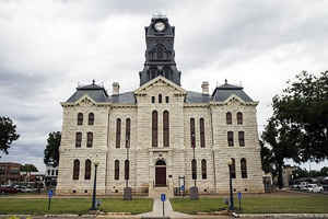
Hood County is a county located on the Edwards Plateau in the state of Texas. Based on the 2010 census, the population was 51,182. Its
county seat is Granbury. The county is named for John Bell Hood, a Confederate lieutenant general and the commander of Hood's Texas
Brigade.
Hood County is part of the Dallas-Fort Worth-Arlington, TX Metropolitan Statistical Area and the Granbury Micropolitan Area.
Etymology - Origin of Hood County Name
John Bell Hood, a Confederate lieutenant general and the commander of Hood's Texas Brigade
Demographics:
County QuickFacts: CensusBureau Quick Facts
Hood County History
Hood County was formed in 1866 from portions of Johnson County.. Its seat is Granbury. Hood County is named for John Bell Hood, a Confederate lieutenant general and the commander of Hood's Texas Brigade.
Handbook of Texas Online
Hood County was formed in November 1866 by an act of the Eleventh Texas Legislature. The area had been within the
Municipality of San Felipe de Austin as early as 1823 and the Municipality of Viesca in 1834. After Texas became a
republic, the area now known as Hood County had, at one time or another, been part of Robertson, Navarro, McLennan,
Johnson, and Erath counties. The county was named after Lt. Gen. John Bell Hood
of the Confederate Army. The county seat was to be named in honor of Confederate general Hiram Bronson Granbury.
Location of the new county seat was a controversial issue. Residents in the southern section of the county favored
the center of the county, as stated in the law. The other choice was a parcel of land donated by influential county
leaders Thomas Lambert and J. F. and J. Nutt. The commission established to designate the county seat, citing a poor
water supply at the center of the county, voted in favor of the donated land. The controversy surrounding the site
of Granbury eventually caused the residents of the southern section of the county to petition for a new county. As a
result, in 1875, Somervell County was established by an act of the Texas legislature. In that same year a fire
destroyed the courthouse in Granbury. From the first days of organized government Hood County has voted Democratic
at the local and state level. Immediately after the Civil War the county was overwhelmingly Democratic, owing mainly
to the predominantly white population. In 1870 whites made up 96 percent of the population. The highest total of
blacks in Hood County was 241 in 1900, or only 3 percent of the population. The last three decades of the nineteenth
century saw a steady increase in the population, and in 1910 the total was just over 10,000. The number of farms
also reached its zenith (1,786) in 1910. The primary crops were cotton, corn, and oats. Numbers of livestock also
reached a peak between 1900 and 1910. In the latter year there were more than 22,500 cattle in Hood County.
Residents were able to send their produce and livestock to market on the Fort Worth and Rio Grande Railway, which
had been completed in 1887 More at
Rhonda L. Callaway, "HOOD COUNTY," Handbook of Texas Online (http://www.tshaonline.org/handbook/online/articles/hch17),
accessed January 24, 2016. Uploaded on June 15, 2010. Published by the Texas State Historical Association.
Geography: Land and Water
As reported by the Census Bureau, the county has a total area of 437 square miles (1,131 km2), of which, 422
square miles (1,092 km2) of it is land and 15 square miles (39 km2) of it (3.48%) is water.
Neighboring Counties
Bordering counties are as follows:
- Parker County (north)
- Johnson County (east)
- Somervell County (south)
- Erath County (west)
- Palo Pinto County (northwest)
Education
The following school districts serve Hood County:
Bluff Dale ISD (mostly in Erath County)
Glen Rose ISD (mostly in Somervell County)
Godley ISD (mostly in Johnson County, small portion in Tarrant County)
Granbury ISD (small portion in Johnson, Parker counties)
Lipan ISD (small portion in Erath, Palo Pinto, and Parker counties)
Tolar ISD


Click Image to Enlarge
