


Click Image to Enlarge
Texas Counties
Texas is divided into two hundred and fifty-four counties, more than any other state. Texas was originally divided into municipalities, a unit of local government under Spanish and Mexican rule. When the Republic of Texas gained its independence in 1836, there were 23 municipalities, which became the original Texas counties. Many of these would later be divided into new counties. The most recent county to be created was Kenedy County in 1921. The most recent county to be organized was Loving County in 1931Hudspeth County, Texas
Hudspeth County Education, Geography, and History
Hudspeth County is a county located in the state of Texas. Based on the 2010 census, the population was 3,476. Its county seat is Sierra
Blanca, and the largest community is Fort Hancock. The county is named for Claude Benton Hudspeth, a state senator and United States
Representative from El Paso. It is northeast from the Mexican border.
Hudspeth County is included in the El Paso, TX Metropolitan Statistical Area. It is one of the nine counties that comprise the Trans-Pecos
region of West Texas. Hudspeth is one of only two Texas counties to observe the Mountain Time Zone.
Etymology - Origin of Hudspeth County Name
Claude Benton Hudspeth, a state congressman, rancher, and newspaper publisher
Demographics:
County QuickFacts: CensusBureau Quick Facts
Hudspeth County History
Prehistoric Jornada Mogollon peoples were practicing agriculture in the Rio Grande floodplain A.D. 900-1350. These
people left behind artifacts and pictographs as evidence of their presence.
The Rodriguez-Sanchez Expedition of 1581 encountered friendly Indians bestowing gifts upon the explorers. Antonio de Espejo 1582-83 expedition
encountered Otomoaco Indians in the county.
The Mescalero Apache frequented the area to irrigate their crops. In 1849 John Salmon "RIP" Ford explored the area between San Antonio and El
Paso noting in his mapped report the productive land upon which the Mescalero Indians farmed. By the mid-17th century the Mescaleros expanded
their territory to the Plains Navajos and Pueblos from the Guadalupes, and El Paso del Norte. Their feared presence deterred white settlers.
In January 1870, a group of soldiers attacked a Mescalero Apache village near Delaware Creek in the Guadalupe Mountains. In July 1880 soldiers
at Tinaja de las Palmas attacked a group of Mescaleros led by Chief Victorio. In August 1880, Buffalo Soldiers ambushed Victorio at
Rattlesnake Springs. Victorio retreated to Mexico and was killed in October by Mexican soldiers. Two weeks later, Apaches killed seven Buffalo
Soldiers, members of the famous black Tenth United States Cavalry.
The demand for new routes from Texas to California caused an uptick in explorations. The San Antonio to El Paso leg of the San
Antonio-California Trail was surveyed in 1848 under the direction of John Coffee Hays. Hudspeth became known as a place travelers passed
through, on their way to somewhere else. Fort Quitman was established in 1858 to provide protection for travelers.
Lt. Francis Theodore Bryan camped at Guadalupe Pass while exploring a route from San Antonio to El Paso via Fredericksburg. Upon reaching El
Paso in July 1849 his report recommended sink wells along the route. In July 1848, Secretary of War William L. Marcy wanted a military post
established on the north side of the Rio Grande. Maj. Jefferson Van Horne was sent out in 1849 to establish Marcy's goal.
John Russell Bartlett was commissioned in 1850 to carry out the Treaty of Guadalupe Hidalgo. Bartlett declared the Guadalupe Mountains dark
and gloomy, and proposed a transcontinental railroad be built south of the peaks. Three years later, Capt. John Pope was sent to scout out a
railroad route, and in the succeeding year to search for artesian water supplies. Texas Commissioner Robert Simpson Neighbors was sent by
Governor Peter Hansborough Bell in 1850 to organize El Paso.
The Butterfield Overland Mail and the San Antonio-San Diego Mail served the county from 1857 to 1861. These mail coaches provided a means for
travelers to reach California in 27 days, if the passenger had the $200 for a one-way fare and was courageous enough to withstand the weather
and dangers en route.
Men from San Elizario and the other villages along the Rio Grande near El Paso had become dependent on the salt trade for their livelihoods.
After the Civil War they broke a road from Fort Quitman to the Salt Basin in northeastern Hudspeth County. But Anglo politicians tried to
capitalize on this trade by asserting ownership of the salt lakes and levying fees on the traders. The result was the 7-year San Elizario Salt
War, which heightened tensions between Mexicans and Americans in the 1870s.
Rival railway companies began competing for rights of way. The Texas and Pacific Railway and the Galveston, Harrisburg and San Antonio
Railwayeventually reached an agreement to share the tracks, with a number of towns arising along the way
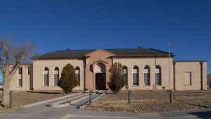
Hudspeth was formed in 1917 from El Paso. Sierra Blanca was named the county seat, and has the only adobe courthouse in the state of Texas. The county is named
for Claude Benton Hudspeth, a state senator from El Paso.
Handbook of Texas Online
A new county was officially organized from eastern El Paso County in February 1917. It was first to have been
called Darlington County, then Turney County, before it was finally named for state senator Claude Benton Hudspeth
of El Paso. Sierra Blanca was made the county seat, and the county courthouse there is the only one in Texas made
entirely of adobe. In 1920 the new county had only 962 inhabitants, but ten
years later the population had climbed to 3,728, due primarily to increased farming. During the 1920s the number of
farms in Hudspeth County increased from thirty-five to 194; whereas in 1920 the county had only 160 improved acres,
by 1930 some 15,700 acres of cropland was harvested. This was, however, the last population boom in Hudspeth County,
as the population fell to 3,149 in 1940, rose to 4,298 in 1950, and then fell again, to 3,343 in 1960 and 2,392 in
1970, before rising slightly to 2,728 in 1980. Farming and ranching have been the primary sources of employment in
Hudspeth County, although the number of people working in agriculture has, with one exception, declined steadily in
every decadal census since 1930: 789 in 1930, 630 in 1940, 960 in 1950, 411 in 1960, 268 in 1970, and 139 in 1980.
Ranching has been the principal activity in Hudspeth County; the national agricultural census showed between 20,000
and 26,000 cattle on local ranches every year except in 1959, when the total was 15,915. The number of sheep grew
from 304 in 1920 to 3,456 in 1930, and to 31,338 ten years later, but declined in subsequent years, to 25,005 in
1950, 19,403 in 1959, and about 4,000 in 1982 More at
Martin Donell Kohout, "HUDSPETH COUNTY," Handbook of Texas Online (http://www.tshaonline.org/handbook/online/articles/hch21),
accessed January 24, 2016. Uploaded on June 15, 2010. Published by the Texas State Historical Association.
Geography: Land and Water
As reported by the Census Bureau, the county has a total area of 4,572 square miles (11,841 km2), of which,
4,571 square miles (11,839 km2) of it is land and 1 square miles (2 km2) of it (0.02%) is water. Part of Guadalupe
Mountains National Park lies in the northeast corner of the county.
Neighboring Counties
Bordering counties are as follows:
- Otero County, New Mexico (north)
- Culberson County (east)
- Jeff Davis County (southeast)
- El Paso County (west)
- Guadalupe, Chihuahua, Mexico (south)
- Pr?edis G. Guerrero, Chihuahua, Mexico (south)
Education
Hudspeth County is served by four school districts. The Fort Hancock Independent School District, based in Fort Hancock, covers the western part of the county, along the El Paso County line from the Mexican border to the New Mexico state line. A strip along the Culberson County line in the eastern part of Hudspeth County which includes Allamoore is served by the Culberson County-Allamoore Independent School District based in Van Horn. Most of the northern part of the county is served by the Dell City Independent School District, based in Dell City. Most of the southern part of the county is served by the Sierra Blanca Independent School District, based in Sierra Blanca.


Click Image to Enlarge
