Texas Counties
Texas is divided into two hundred and fifty-four counties, more than any other state. Texas was originally divided into municipalities, a unit of local government under Spanish and Mexican rule. When the Republic of Texas gained its independence in 1836, there were 23 municipalities, which became the original Texas counties. Many of these would later be divided into new counties. The most recent county to be created was Kenedy County in 1921. The most recent county to be organized was Loving County in 1931Jones County, Texas
Jones County Education, Geography, and History

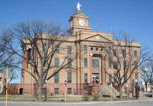
Jones County is a county located in the state of Texas. Based on the 2010 census, its population was 20,202. Its county seat is Anson. The
county was created in 1858 and organized in 1881. Both the county and its county seat are named for Anson Jones, the fifth president of the
Republic of Texas. Jones County is one of 46 prohibition, or entirely dry, counties in the state of Texas.
Jones County is included in the Abilene, TX Metropolitan Statistical Area.
Etymology - Origin of Jones County Name
Anson Jones, the fifth president of the Republic of Texas
Demographics:
County QuickFacts: CensusBureau Quick Facts
Jones County History
Jones County is a county located in the US state of Texas. Its county seat is Anson. Both the county and its county seat are named for Anson Jones, the fifth president of the Republic of Texas
Handbook of Texas Online
In the years before Anglo settlement, several nomadic groups roamed the area that would eventually become Jones
County, including the Comanche, Kiowa, and Tonkawa Indians. Caddos and Delawares camped along the Clear Fork, and
Wichitas occasionally hunted in the area. Large herds of bison provided food and other necessities for these Indian
groups. The earliest white settlement of Jones County was in 1851 when Fort Phantom Hill, near the site of present
Hawley, was established as one of a line of forts from the Red River to the Rio Grande. These military outposts
guarded the frontier and furnished protection to Forty-niners following the Randolph B. Marcy
trail across Texas. Supplies were hauled from Austin. The fort was abandoned in 1854, and in 1858 the location was
made a station on the Butterfield Overland Mail route from St. Louis to San
Francisco. Jones County was established on February 1, 1858, from Bexar and Bosque counties. During the Civil War
Indian raids forced the frontier back to the east, and the area was not settled for another fifteen years. In 1872
the military post was reestablished, and a settlement was made on a stream four miles distant. The actions of Ranald
S. Mackenzie and federal troops removed the Indian threat in the mid-1870s.
Buffalo hunters were followed by bone haulers, and the last buffalo was seen in the county in 1879. Owners of herds
of longhorn cattle moved in to take advantage of the grass-covered range. In
1873 Creed, John, and Emmett Roberts and Mode and J. G. Johnson established ranches in the area of Fort Phantom
Hill. Other early ranches included the T-Diamond, established in 1876, and the Ericsdale Ranch of the Swenson Land
and Cattle Company, established in 1882 (see SMS RANCHES). In 1880 John Merchant built a mesquite corral at
the site of the future county seat, and Henry Foster put up the first wire fence in the county. The population of
Jones County reached 546 that year, and when the county was organized in 1881 Jones City was declared the county
seat. In 1882 the name of the county seat was changed to Anson. More at
Mark Odintz, "JONES COUNTY," Handbook of Texas Online (http://www.tshaonline.org/handbook/online/articles/hcj09),
accessed January 24, 2016. Uploaded on June 15, 2010. Published by the Texas State Historical Association.
Geography: Land and Water
As reported by the Census Bureau, the county has a total area of 937 square miles (2,427 km2), of which, 931
square miles (2,411 km2) of it is land and 6 square miles (16 km2) of it (0.66%) is water.
Neighboring Counties
Bordering counties are as follows:
- Haskell County (north)
- Shackelford County (east)
- Callahan County (southeast)
- Taylor County (south)
- Fisher County (west)
- Stonewall County (northwest)
Education


