


Click Image to Enlarge
Texas Counties
Texas is divided into two hundred and fifty-four counties, more than any other state. Texas was originally divided into municipalities, a unit of local government under Spanish and Mexican rule. When the Republic of Texas gained its independence in 1836, there were 23 municipalities, which became the original Texas counties. Many of these would later be divided into new counties. The most recent county to be created was Kenedy County in 1921. The most recent county to be organized was Loving County in 1931Maverick County, Texas
Maverick County Education, Geography, and History
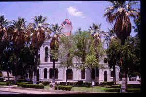
Maverick County is a county located in the state of Texas. Based on the 2010 census, its population was 54,258. Its county seat is Eagle
Pass. The county was created in 1856 and organized in 1871It is named for Samuel Maverick, cattleman and state legislator.
The Eagle Pass, TX Micropolitan Statistical Area includes all of Maverick County. It is east from the Mexican border.
Etymology - Origin of Maverick County Name
Samuel Augustus Maverick, an early legislator and later rancher near the future county; from his name the word "maverick" entered the English lexicon due to his practice of not branding his cattle as well as his stubborn independence in refusing to do so
Demographics:
County QuickFacts: CensusBureau Quick Facts
Maverick County History
Prehistoric hunter-gatherer peoples were the first inhabitants, and their artifacts have been found in various
areas of the county. Lipan Apache, Shawnee, and Coahuiltecan culture followed. The abandonment of Fort Duncan on March 20, 1861, during the
Civil War, enabled the Indian population to gain control of the region; both American and Mexican inhabitants suffered tremendous loss of life
and property. The fort was reoccupied in 1868. In early 1871, a number of Black Seminole Indians living along the border were organized into a
company of scouts and brought to Fort Duncan. The last Indian raid in the county occurred in 1877. Three traders were murdered and mutilated
by Lipan Apaches. The site of the incident, eight miles (13 km) northeast of Eagle Pass, became known as Deadman's Hill.
The El Camino Real, later known as the Old San Antonio Road, that crosses the Rio Grande, begins in East Texas and crosses southern Maverick
County. The trail was originally blazed by Alonso De León in 1690, and is said to have been traversed by more early Spanish explorers and
settlers than any other section of the state. In 1989, the legislature authorized the Old San Antonio Road Preservation Commission to
coordinate the 1991 300th anniversary of the trail's founding.
Saltillo alcade Fernando de Azcué in 1665 pursued Indians into the county. In 1675, Fernando del Bosque traversed the area near Quemado, and
Franciscans with the expedition are said to have celebrated the first Mass on Texas soil. In 1688, Alonso De León followed the Camino Real
across the county en route to Fort St. Louis. Domingo Terán de los Ríos, the first Governor of Spanish Texas, led an expedition through the
county in 1691. Spanish Texas Governor Martín de Alarcón crossed the county in 1718 on the expedition that resulted in the founding of San
Antonio. Governor of the Mexican provinces of Coahuila and Texas, Marqués de San Miguel de Aguayo, in 1720 passed through on an expedition
that brought goats, 2800 horses and 6400 sheep that was the onset of Spanish ranching in Texas. Pedro de Rivera y Villalon crossed the county
in 1727 as part of an expedition to inspect the frontier defenses of New Spain.
Antonio Rivas was the first known rancher on the land in 1765. The county still has a considerable ranching community.
On March 27, 1849, Capt. Sidney Burbank established Fort Duncan, previously known as Camp Eagle Pass, on a site two miles (3 km) north of the
ford at Adjuntos Pass.
General William Leslie Cazneau, credited several years earlier with burying the Alamo casualties with full military honors, began ranching in
the area around 1850. He partnered with Irish-born San Antonio banker and county settler John Twohig to lay out a plan of Eagle Pass in 1850.
That same year, a Mexican garrison established Piedras Negras across the border.
Freight operator Friedrich Wilhelm Carl Groos secured a contract to haul supplies for the army at Fort Duncan. At his urging, several early
settlers of Eagle Pass were emigres of the Mexican river villages and missions of San Juan Bautista, San José, Santo Domingo, San Nicolás, La
Navaja, and San Isidro.
Emigres Refugio and Rita Alderete de San Miguel used the profits of their freighting business to establish a large-scale cattle, sheep, and
horse ranch on Elm Creek in 1853. They were joined in ranching operations by stranded pilgrims on the California Gold Rush trail and
discharged Fort Duncan soldiers. Among these was Infantry veteran Jesse Sumpter, who also worked at many odd jobs before becoming sheriff in
the newly formed Maverick County.
Landscape pioneer Frederick Law Olmsted visited Eagle Pass in 1854, and noted the many slave hunters and runaway slaves residing in Piedras
Negras, as well as the many saloons and gambling houses, which catered to Fort Duncan's soldiers and other unsavory characters.
In 1855, Texas Governor Elisha M. Pease authorized a raid into Mexico. An international incident was brought about by James H. Callahan and
William R. Henry, whose pursuit of Lipan Apache raiders and runaway slaves into Mexico ended in the looting and torching of Piedras Negras,
after an encounter with Mexican forces at La Marama on the Río Escondido.
Maverick County was established from Kinney County and named for Samuel A. Maverick in 1856. The county was organized some years later on
September 4, 1871. Maverick County is
named for Samuel Maverick, cattleman and state legislator.
Handbook of Texas Online
Maverick County was carved from Kinney County and named for Samuel A. Maverick in 1856. The estimated population
of the county in 1860 was 726. The vote of Eagle Pass against secession from the
Union was an overwhelming eighty to three. Fort Duncan was occupied by Confederate troops during the Civil War.
Eagle Pass was chosen as a trade depot for the Military Board of Texas. Near the
end of the war Eagle Pass was the only port of entry open for the export of the Confederacy's cotton. Friedrich
Groos, who had a flourishing mercantile and freighting business at Eagle Pass when the war began, had switched to
trading cotton and running a cotton yard by 1863. So much cotton was passing through Eagle Pass by 1864 that cotton
bales were lined from the river to the edge of town. A cotton press was installed at Piedras Negras to handle the
enormous quantities coming across the Rio Grande. At the close of the war Gen. Joseph Orville Shelby (see
SHELBY EXPEDITION) bivouacked 500 Confederate soldiers of the Trans-Mississippi Army in the Eagle Pass area. On July
4, 1865, when crossing the Rio Grande on the way to Mexico to offer his troops' service to Maximillian, Shelby
stopped in the middle of the river to bury the last Confederate flag to fly over his troops. According to his
adjutant, he wrapped the flag around the plume of his hat, weighted it with a stone from the river bank, and lowered
it into the river. More at
Ruben E. Ochoa, "MAVERICK COUNTY," Handbook of Texas Online (http://www.tshaonline.org/handbook/online/articles/hcm06),
accessed January 24, 2016. Uploaded on June 15, 2010. Modified on November 25, 2013. Published by the Texas State Historical Association.
Geography: Land and Water
As reported by the Census Bureau, the county has a total area of 1,292 square miles (3,346 km2), of which,
1,280 square miles (3,315 km2) of it is land and 12 square miles (31 km2) of it is water. The total area is 0.90%
water.
Neighboring Counties
Bordering counties are as follows:
- Kinney County (north)
- Zavala County (east)
- Dimmit County (east)
- Webb County (southeast)
- Guerrero, Coahuila, Mexico (southwest)
- Jim?ez, Coahuila, Mexico (west)
- Piedras Negras, Coahuila, Mexico (southwest)
Education
All of Maverick County is served by the Eagle Pass Independent School District.
Sul Ross State University and South West Texas Junior college also serve this community.


Click Image to Enlarge
