


Click Image to Enlarge
Texas Counties
Texas is divided into two hundred and fifty-four counties, more than any other state. Texas was originally divided into municipalities, a unit of local government under Spanish and Mexican rule. When the Republic of Texas gained its independence in 1836, there were 23 municipalities, which became the original Texas counties. Many of these would later be divided into new counties. The most recent county to be created was Kenedy County in 1921. The most recent county to be organized was Loving County in 1931McCulloch County, Texas
McCulloch County Education, Geography, and History
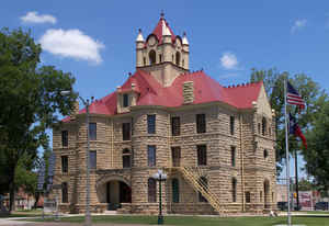
McCulloch County is a county located on the Edwards Plateau in the state of Texas. Based on the 2010 census, its population was 8,283. Its
county seat is Brady. The county was created in 1856 and later organized in 1876. It is named for Benjamin McCulloch, a famous Texas Ranger
and Confederate general.
The geographical center of Texas lies within McCulloch County, near Brady.
Etymology - Origin of McCulloch County Name
Benjamin McCulloch, a famous Texas Ranger and Confederate general who was killed at the Battle of Pea Ridge (Battle of Elkhorn Tavern)
Demographics:
County QuickFacts: CensusBureau Quick Facts
McCulloch County History
McCulloch County is a county located in the US state of Texas. Its county seat is Brady. McCulloch is named for Benjamin McCulloch, a famous Texas Ranger and Confederate general.
Handbook of Texas Online
The Sixth Legislature formed McCulloch County from the Bexar District in 1856 and named it in honor of Benjamin
McCulloch. In the late 1850s a few families came to the Lost Creek area and to
the sites of present Milburn and Camp San Saba, but the population remained too small for permanent organization of
the county. In 1860 McCulloch County was attached to San Saba County for judicial purposes. Some officials were
elected for McCulloch County in the 1860s, and evidence suggests that the Voca and Lost Creek communities were the
center of county affairs during these years, but it was not until 1876 that all of the county offices were filled
and a county seat was chosen. McCulloch County was not organized in time to have a representative at the secession
convention of 1861, and its involvement in the Civil War
was limited. Indians, not Yankees, presented the more immediate threat to people who had settled there by the 1860s.
Confederate volunteers from McCulloch and other frontier counties were stationed at such outposts as Camp San Saba
to protect settlers from Indians after federal troops withdrew from the area in 1861. The greatest impact that the
Civil War and Reconstruction had on the development of McCulloch County was in
providing incentive to families from other southern states to come west and start again More at
Vivian Elizabeth Smyrl, "MCCULLOCH COUNTY," Handbook of Texas Online (http://www.tshaonline.org/handbook/online/articles/hcm07),
accessed January 24, 2016. Uploaded on June 15, 2010. Published by the Texas State Historical Association.
Geography: Land and Water
As reported by the Census Bureau, the county has a total area of 1,073 square miles (2,780 km2), of which,
1,069 square miles (2,770 km2) of it is land and 4 square miles (10 km2) of it (0.38%) is water.
Neighboring Counties
Bordering counties are as follows:
- Coleman County (north)
- Brown County (northeast)
- San Saba County (east)
- Mason County (south)
- Menard County (southwest)
- Concho County (west)
Education
The following school districts serve McCulloch County:
Brady ISD (small portion in Concho County)
Lohn ISD
Mason ISD (mostly in Mason County; small portions in Kimble, Menard, and San Saba counties)
Rochelle ISD


Click Image to Enlarge
