


Click Image to Enlarge
Texas Counties
Texas is divided into two hundred and fifty-four counties, more than any other state. Texas was originally divided into municipalities, a unit of local government under Spanish and Mexican rule. When the Republic of Texas gained its independence in 1836, there were 23 municipalities, which became the original Texas counties. Many of these would later be divided into new counties. The most recent county to be created was Kenedy County in 1921. The most recent county to be organized was Loving County in 1931Medina County, Texas
Medina County Education, Geography, and History
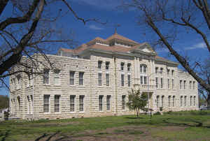
Medina County is a county located in the state of Texas. Based on the 2010 census, its population was 46,006. Its county seat is Hondo. The
county is named for the Medina River.
The Medina Dam, the fourth largest in the nation when completed in 1913, is listed on the National Register of Historic Places. The irrigation
project, creating Medina Lake, was built by 1500 skilled workers who worked in shifts operating 24 hours a day to complete the dam in two
years.
Medina County is part of the San Antonio, TX Metropolitan Statistical Area.
Etymology - Origin of Medina County Name
the Medina River. Named after Pedro Medina, a Spanish engineer, by Alonso de Leon, Spanish governor of Coahuila, New Spain in 1689. It was also known as the Rio Mariano, Rio San Jose, or Rio de Bagres (Catfish river).
Demographics:
County QuickFacts: CensusBureau Quick Facts
Medina County History
Medina County is a county located in the US state of Texas. Its seat is Hondo. The county is named for the Medina River.
Handbook of Texas Online
Medina County was separated from Bexar County by the legislature on February 12, 1848, and enlarged on February
1, 1850, again gaining lands from Bexar County. At this time the population of Medina County was estimated to be
predominantly Catholic at a ratio of five out of every six people. The first church in the county, the Catholic
Church of St. Louis Parish in Castroville, was completed in November 1846. The Lutherans organized churches at
Castroville and Quihi in 1852 and 1854. The Catholic church organized a school in Castroville in 1845; the
Protestants did likewise in 1854. The first public school in Medina County was also established in Castroville in
1854. By 1858 the county had five schools for 453 pupils and five churches, three Protestant and two Catholic. A
short-lived Mormon community was established in northeastern Medina County in 1854. By 1858 stock raising and the
cultivation of corn were the chief agricultural pursuits in the county. Much of the labor needed to clear the land
for homes and farms was done by Mexican laborers. Statistics taken in that year show 10,000 acres of corn planted
and 100 acres of wheat on 240 farms; there were 11,000 cattle, principally in the Castroville, D'Hanis, Quihi, and
Vandenburg areas; sheep were raised principally in the northern hilly and rocky areas. Peach trees were abundant;
cypress and pecan grew along streams and rivers; mesquite, live oak, post oak, and cedar were prevalent trees in the
prairies. Castroville, with a population of 366, was the twelfth-largest town in Texas and an important commercial
center by 1850. Fort Lincoln had been erected in 1849 near Old D'Hanis to furnish protection for the new settlements
and commercial traffic between San Antonio and Mexico. Most settlers operated subsistence farms while they learned
stock raising, which many realized was best suited to the area. The typical diet consisted of corn-meal mush, garden
vegetables, and wild game. In 1850 there were only twenty-eight slaves in the estimated 909 citizens of Medina
County. In 1858 the estimated population of 1,300 included 104 slaves. In 1860 there were 108 slaves. Two conditions
in Medina County served as a deterrent to slavery; its proximity to Mexico
offered sanctuary for runaway slaves, and the Unionist sentiment disfavoring the institution of slavery was general
among the European settlers. In February 1861 the vote was 140 for and 207 against secession.
August Santleben, a Union sympathizer, was one of many Medina County citizens
who fled to Mexico to avoid recriminations at the hands of Confederate allies like Charles DeMontel,
who as provost marshal was responsible for apprehending those who attempted to escape Confederate service. The value
of Medina County land during the Civil War dropped by almost 50 percent. Education and schools suffered during the
war as funding plummeted. However, communities like Castroville, situated on the commercial routes to Mexico,
prospered. After the war a number of German immigrants arrived. By 1870 a majority of the 2,078 people in the county
were of German or French origin; there were ninety-two blacks, forty Mississippians, and thirty-three Mexicans More at
Ruben E. Ochoa, "MEDINA COUNTY," Handbook of Texas Online (http://www.tshaonline.org/handbook/online/articles/hcm10),
accessed January 24, 2016. Uploaded on June 15, 2010. Published by the Texas State Historical Association.
Geography: Land and Water
As reported by the Census Bureau, the county has a total area of 1,335 square miles (3,456 km2), of which,
1,328 square miles (3,439 km2) of it is land and 7 square miles (17 km2) of it (0.51%) is water.
Neighboring Counties
Bordering counties are as follows:
- Bandera County (north)
- Bexar County (east)
- Atascosa County (southeast)
- Frio County (south)
- Uvalde County (west)
Education


Click Image to Enlarge
