


Click Image to Enlarge
Texas Counties
Texas is divided into two hundred and fifty-four counties, more than any other state. Texas was originally divided into municipalities, a unit of local government under Spanish and Mexican rule. When the Republic of Texas gained its independence in 1836, there were 23 municipalities, which became the original Texas counties. Many of these would later be divided into new counties. The most recent county to be created was Kenedy County in 1921. The most recent county to be organized was Loving County in 1931Navarro County, Texas
Navarro County Education, Geography, and History
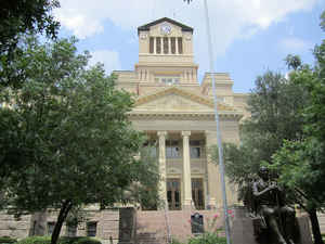
Navarro County is a county located in the state of Texas. Based on the 2010 census, the population was 47,735. Its county seat is Corsicana.
The county is named for José Antonio Navarro, a Tejano leader in the Texas Revolution who signed the Texas Declaration of Independence.
Navarro County comprises the Coriscana, TX Micropolitan Statistical Area, which is also included in the Dallas-Fort Worth, TX Combined
Statistical Area.
Etymology - Origin of Navarro County Name
Jose Antonio Navarro, a leading Tejano participant in the Texas Revolution and signer of the Texas Declaration of Independence
Demographics:
County QuickFacts: CensusBureau Quick Facts
Navarro County History
Navarro County was formed from Robertson County in 1846. Its county seat is Corsicana. Navarro County is named for Jose Antonio Navarro, a Tejano leader in the Texas Revolution who signed the Texas Declaration of Independence.
Handbook of Texas Online
In the spring of 1839 more families moved in and settled around the trading post. Two growing settlements were
Porter's Bluff and Dresden. All of the legal work for the two sites was conducted at Franklin, the county seat of
Robertson County, 125 miles south of Hill's Trading Post. People in Porter's Bluff and Dresden felt they needed
their own county with a local authority to handle legal matters. In the spring of 1846 a group led by Edward H.
Tarrant, a Texas Ranger, met at the home of Thomas I. Smith.
The men at the meeting drew up a petition for a new county to be made out of Robertson County, with a temporary
county seat to be located at the home of W. R. Howe. Clinton M. Winkler, a local
lawyer, presented the petition to the state legislature in Austin, and it was approved on April 25, 1846. The new
county included all the portion of Robertson County within the east bank of the Brazos River to the northwest corner
of Limestone County. It also extended to the Trinity River and north to Dallas County. It was named Navarro County
in honor of Jos?Antonio Navarro, a Texas patriot. The county seat remained at
Howe's home until his death in 1847. On February 8, 1848, a committee headed by Tarrant voted to set up a permanent
county seat at the halfway point between Porter's Bluff and Dresden. Rev. Hampton McKinney was already living at the
site and later constructed the McKinney Inn at the location. On February 25, 1848, Thomas Smith donated 100 acres of
land at the McKinney site, and C. C. Taylor was employed to construct a town plot. Jos?Antonio Navarro chose the
name Corsicana in honor of the Isle of Corsica, his father's birthplace. The town is located forty-five miles
southeast of Dallas on Interstate Highway 45. Over the next twenty years the original Navarro County was divided
into the following counties: Limestone in 1846, Ellis in 1847, Tarrant in 1847, part of McLennan in 1850, Hill in
1853, Johnson More at
,Julie G. Miller, "NAVARRO COUNTY," Handbook of Texas Online (http://www.tshaonline.org/handbook/online/articles/hcn02),
accessed January 24, 2016. Uploaded on June 15, 2010. Published by the Texas State Historical Association.
Geography: Land and Water
As reported by the Census Bureau, the county has a total area of 1,086 square miles (2,813 km2), of which,
1,008 square miles (2,610 km2) of it is land and 79 square miles (203 km2) of it (7.23%) is water.
Neighboring Counties
Bordering counties are as follows:
- Henderson County (northeast)
- Freestone County (southeast)
- Limestone County (south)
- Hill County (southwest)
- Ellis County (northwest)
Education


Click Image to Enlarge
